Three big weather changes: 100s in the Southwest, break from Southern storms, Northeast gloom departs


By Chris Dolce I Weather.com
The northern branch of the jet stream will reconfigure itself this week, allowing for some significant weather changes to occur from coast-to-coast. This includes a big warm-up in the West and Plains, a break from stormy weather in the South and some warmer temperatures in the Northeast.
Below is our in-depth look at the big changes coming your way.
#1.) 100s in the Southwest; Midwest Warm-Up
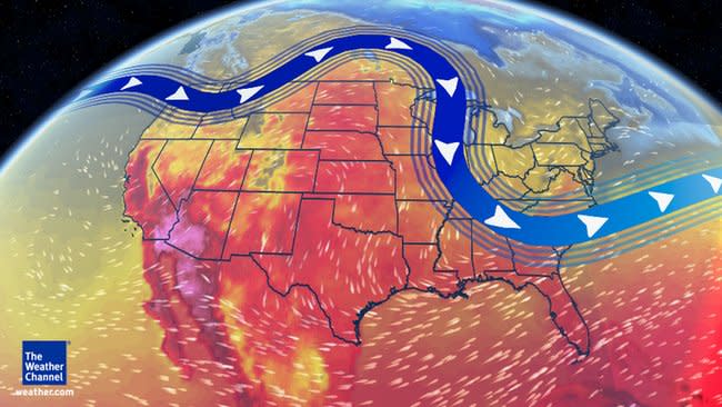
Midweek Weather Pattern
The jet stream will lift northward allowing warm temperatures to takeover in the West and Plains.
A southward dip in the jet stream across the West and the Plains to start the week will be replaced by an upper-level ridge by midweek. The end result is that temperatures will be on an upward swing across these regions. In fact, highs in the 100s are not out of the question in the Desert Southwest, while upper 70s and low 80s return to the northern Plains.
Specifics:
Phoenix: After topping out in the middle 70s on Sunday, it will be near 100 degrees Thursday and Friday. The average first 100-degree day in Phoenix occurs around May 2.
Billings, Montana: Sunday's high was only 41 degrees. Temperatures will be in the 70s on Tuesday and low 80s on Wednesday.
Minneapolis/St. Paul: Following cooler-than-average conditions much of last week, highs in the upper 60s or 70s are expected this week.
(MAPS: Forecast Temperatures This Week)
#2.) Southern Storminess Takes a Break
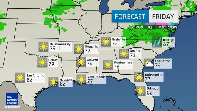
Friday's Forecast
Parts of the southern Plains, Gulf Coast and Southeast have dealt with repeated rounds of rain and thunderstorms the last couple of weeks. These storms have produced tornadoes, large hail, wind damage and flash flooding at times.
Although the week will start out with more severe storms and heavy rain affecting parts of the region, we see drier conditions in the not so distant future. Below is a look at how the drier weather pattern will take shape from west-to-east across the South.
(MORE: This Week's Severe Threat)
Specifics:
South-Central States: Showers and thunderstorms will continue to impact parts of Oklahoma, Texas, Louisiana and Arkansas into Tuesday. After Tuesday, dry conditions will dominate into the weekend.
Gulf Coast: Showers and storms will spread through the Gulf Coast into Tuesday. By late Wednesday drier weather will take over and remain in place through the weekend.
Southeast: Wet conditions will spread through the Southeast and parts of Florida Tuesday and Wednesday. Depending on how slow the area of low pressure moves through the region, we may not see completely dry conditions return until Friday or Saturday, especially in parts of the Carolinas and Florida. The dry weather will persist through Sunday.
#3.) Northeast Warms Tuesday and Wednesday

Forecast This Week
Weather conditions in the Northeast started out gloomy with below-average temperatures and scattered showers on Monday, particularly across the interior. This follows a cool finish to last week in the region with many cities experiencing below-average temperatures.
An area of low pressure in the upper atmosphere that was centered near Nova Scotia on Monday is now shifting east. This should allow warmer temperatures to take shape Tuesday into Wednesday in the Northeast. The lone exception will be portions of eastern and northern New England.
The bad news is that this change to a warmer weather pattern won't stick around for long. Another dip in the jet stream will nudge temperatures downward Thursday into Friday.
A second change to the large-scale weather pattern will arrive this weekend in the Northeast. The jet stream will lift northward Saturday and Sunday, allowing temperatures to rise above average once again.
Specifics:
New York City: The high temperature on Wednesday may rise above 70 degrees for the first time since April 18. After cooling down Thursday and Friday, the Big Apple will make a run at 70 degrees once again on Sunday.
Philadelphia: After enduring highs in the 50s late last week through the weekend, Philly will see upper 60s or low 70s Tuesday and Wednesday. Temperatures will swing downward Thursday and Friday, and then a warm-up will take shape this weekend.
Pittsburgh: Monday was the sixth consecutive day that the high temperature stayed below average in Pittsburgh. Starting Tuesday and continuing through the weekend, we will see 60s make a return. A few days may even top out near 70 degrees.
More to see:
Stephen Hawking says humans won't last another 1,000 years on Earth
Boston bomber's lawyers to probe Tsarnaev's troubled history
Nominations for the 2015 Tony Awards announced
