1st week of September to be a soaker in the southern US


AccuWeather meteorologists advise that residents and visitors in the southern United States should keep their umbrellas ready; as the calendar flips to September, a weather pattern bringing frequent downpours is expected to continue through much of the week.
"Persistent winds coming off the Gulf of Mexico will funnel moisture northward across the South through much of this week. While this will help with the ongoing drought across portions of Mississippi, Alabama and Louisiana, it will also increase the risk for localized flash flooding issues across the region," AccuWeather Meteorologist Brandon Buckingham said.
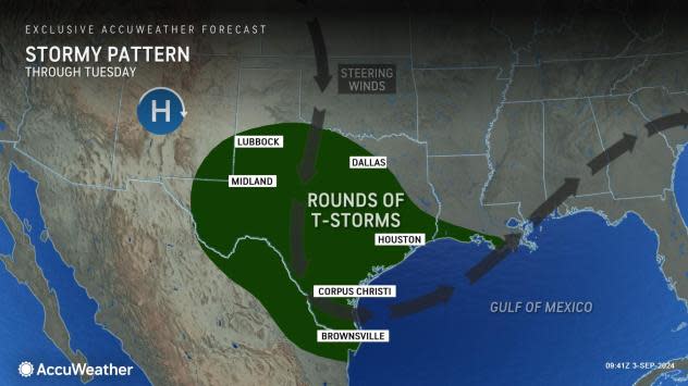
Showers and thunderstorms will tend to congregate and grow in coverage near notable weather features. These include a cold front that will slow down and stall early this week across the Carolinas, as well as a an influx of tropical moisture bringing wave after wave of rain to much of Texas and southeastern Louisiana through Tuesday.
 |
"Showers, thunderstorms and localized torrential downpours will extend from northwestern Texas to the Gulf Coast," AccuWeather Senior Meteorologist Alex Sosnowski said. This includes places such as Houston and perhaps Dallas.
Have the app? Unlock AccuWeather Alerts™ with Premium+
There may be a relative minimum in thunderstorm activity across parts of northeastern Texas, northern Louisiana, Mississippi and Alabama; even still, there may be a thunderstorm or two in the area.
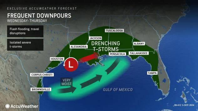
Toward the middle and latter part of this week, downpours will tend to slowly wander eastward across the Southern states, including more of the lower Mississippi Valley and interior Southeast.
 |
This eastward shift will bring some relief to central and western Texas, but continue to threaten the Texas Gulf Coast with rain. It's also not out of the question that some thunderstorms could also turn severe, bringing the risk of damaging wind gusts.
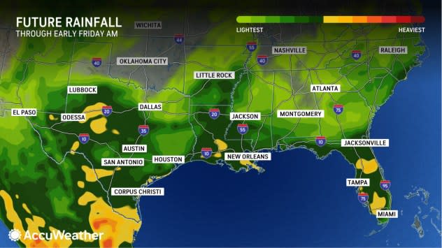
The wettest spots will likely be over the western Gulf Coast states, where 4-8 inches of rain may fall into the middle of this week, according to Sosnowski.
Drivers planning to travel along sections of interstates 10, 20, and 35 should anticipate slower traffic at times through much of this week due to downpours reducing visibility.
 |
The weather pattern is also unfavorable for beachgoers. In addition to dodging raindrops, those heading to the water will encounter an increased risk of rough surf and more frequent rip currents along both the northwestern Gulf Coast and the southern Atlantic Seaboard.
Toward the latter part of this week and heading into next weekend, there is the potential for a tropical feature to track northward from the Caribbean Sea and into the Gulf of Mexico.
There is likely to continue to be an enhancement in downpours, especially for coastal communities, heading into the upcoming weekend, regardless of whether there is a named tropical entity.
Want next-level safety, ad-free? Unlock advanced, hyperlocal severe weather alerts when you subscribe to Premium+ on the AccuWeather app. AccuWeather Alerts™ are prompted by our expert meteorologists who monitor and analyze dangerous weather risks 24/7 to keep you and your family safer.
