Beaufort County under tropical storm warning as Tropical Storm Debby moves across Florida
Making landfall over Florida’s Big Bend region at 7 a.m. Monday as a Category 1 storm, forecasters expected Hurricane Debby to dump historic rainfall to the Lowcountry as it moved slowly up the Southeast coast.
At 11 a.m., Debby was downgraded to a tropical storm, according to the National Hurricane Center. The storm was 35 miles west of Lake City, Florida. Tropical Storm Debby had sustained winds of 70 mph and was moving at 8 mph. As the storm moves inland, it will weaken Monday and Tuesday, according to the center.
Early Monday morning, the National Weather Service issued a tropical storm warning for Hilton Head, Beaufort and Bluffton, meaning sustained winds of 39 to 73 mph or higher associated with a tropical cyclone are expected in 36 hours or less. Tuesday morning is the earliest Beaufort County could see tropical storm-force winds. The warning was set to expire at 7:15 p.m.
At 11:15 a.m., thw NWS issued a tornado watch, which is set to expire at 4 p.m. A watch indicates that tornadoes are possible in and near the watch area.
If high winds come to the area, the earliest they’d arrive is Monday and could bring winds up to 57 mph. The service also reported that tornadoes are possible for areas mainly near the state’s coast and dangerous marine conditions are expected.
NWS’ Charleston office said the slow-moving storm “will bring a prolonged period of impacts through mid-to-late week,” which could be catastrophic.
Hilton Head, Bluffton and Beaufort are expected to get about 20 inches of rain, with the possibility of local amounts up to 30 inches, from the tropical system through Thursday, according to updated maps from the NWS at 6 a.m. Monday. Widespread severe flash flooding is likely for much of the area, the service said.
“For an event of this duration, these amounts have a 0.2% to 0.1% chance of happening in any given year,” the NWS wrote in an 11:30 a.m. briefing.
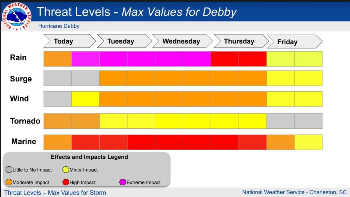
The county was also under a storm surge warning, which is triggered 36 hours before the potential for hazardous flooding conditions. Between 2 and 4 feet of storm surge inundation over normally dry tidal/near tidal regions is possible, according to local meteorologists. Coastal flooding from storm surge and above-average astronomical tides will likely affect some or all of South Carolina’s coast Tuesday through Thursday, said Frank Strait, the state’s severe weather liaison.
With large amounts of rainfall possible as early as Monday, it could cause flash flooding or ponding on roadways, South Carolina’s Department of Transportation said. The agency urged the public never to drive through standing water.
On Sunday afternoon, Gov. Henry McMaster declared a State of Emergency in preparation for the potential effects of the storm.
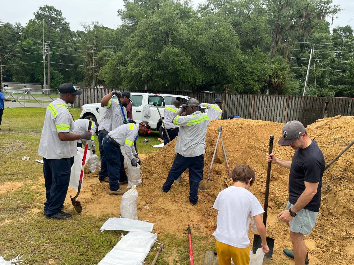
In preparation for predicted “historic” rainfall, Beaufort County continued to offer free sandbag-filling stations. The stations will be open between 10 a.m. and 4 p.m. Monday while supplies last. The public is encouraged to bring their own bags and shovels, a news release from the county said. Bags and sand are on a first-come, first-serve basis.
Sandbag-filling stations are located at:
9 Benton Field Road in Bluffton
80 Shanklin Road in Beaufort
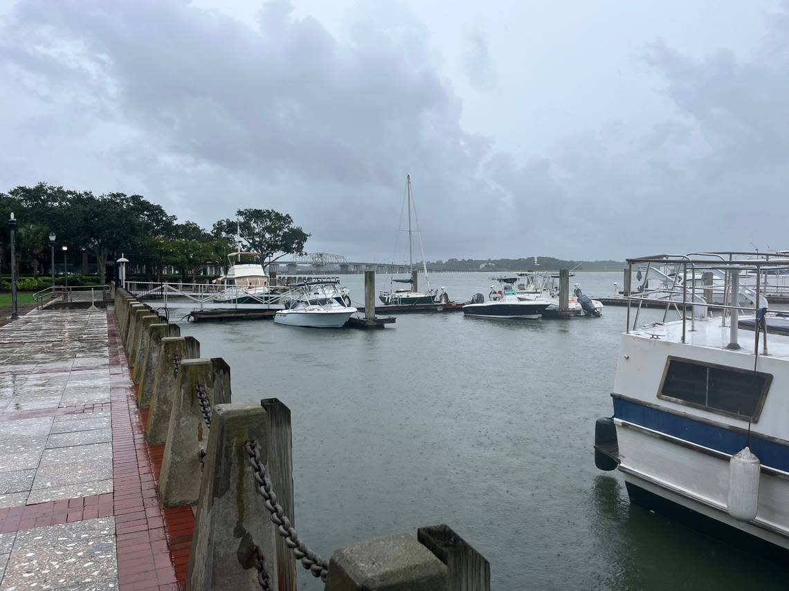
On Sunday night, the Town of Hilton Head Island said it had prepared for potential impacts from Debby, including clearing storm drains, securing equipment to prepare for closures, and removing trash and debris.
“Our Town is ready to respond to the storm and began as soon as last week making plans to deal with potential flooding and heavy rain,” Mayor Alan Perry said in a Sunday news release. “I have confidence in our town’s ability to face and overcome the challenges posed by this tropical storm.”
In response to the impending storm, the town will hold a press conference at 11 a.m. Monday with Perry and Emergency Manager Tom Dunn.
Sunday afternoon, the City of Beaufort said Capital Waste will conduct Monday’s route as normal, according to a news release. Starting Tuesday and through Friday, routes may be affected due to the wind and flooding.
The Greenery removed tables, chairs and trash cans from the Waterfront Park Monday morning. Trash cans were also removed from Bay Street to Craven Street. Public restrooms will remain open until 5 p.m. Monday, the city said.
As of 8 a.m. Monday, South Carolina’s Emergency Management Division didn’t report any closings in Beaufort County. According to PowerOutage.us, there weren’t any customers in the county without power.
NWS explains impacts
Wind
Damage to porches, awnings, carports, sheds, and unanchored mobile homes
Unsecured lightweight objects blown about
A few trees snapped or uprooted
Some roads impassable due to debris, particularly within urban or heavily wooded locations
Hazardous driving conditions on bridges and other elevated roadways, especially for high profile vehicles
Isolated to scattered power and communications outages
Storm surge
Areas of inundation of saltwater along immediate shorelines and in low-lying spots farther inland near rivers and creeks, with storm surge flooding accentuated by waves
Damage to several buildings, mainly near the coast
Sections of near-shore escape routes and secondary roads become weakened or washed out, especially in normally vulnerable low spots
Moderate to major beach erosion with heavy surf breaching dunes
Strong and numerous rip currents
Minor to moderate damage to marinas, docks, boardwalks and piers
Several small craft broken away from moorings, especially in unprotected anchorages
Some navigation aids possibly displaced well off station, creating difficult navigation near inlets and waterways
Flooding rain
Small streams, creeks, canals, and ditches may become raging rivers with strong currents
Flood control systems and barriers could become stressed or overwhelmed
Flood waters will enter many structures within multiple communities, some structures becoming uninhabitable or washed away
Flood waters could render escape routes impassable
Streets and parking lots become rivers of raging water with underpasses submerged
Driving conditions become impossible and life threatening
Widespread road and bridge closures with most weakened or washed out
Drinking water and sewer services could be negatively impacted
Hazardous containers and materials could possibly be present in flood waters
Tornado
Isolated tornadoes can hinder the execution of emergency plans
Isolated locations could experience tornado damage, along with power and communications disruptions
In isolated locations, tornadoes could damage trees, vehicles, boats and buildings, especially mobile homes and other poorly constructed structures
How to prepare
The Beaufort County Sheriff’s Department shared the following tips to prepare for the incoming weather system.
Secure outdoor items such as trash cans, patio furniture, hanging planters, and any other items that may become airborne
Ensure all drains near your home are free of debris
Keep in mind when preparing your animals ahead of the storm, that it’s against the law to abandon or tether an animal during a named storm
Stay off the roads unless it’s necessary to travel
Do not drive through flooded roads
When crossing elevated roads and bridges is not safe during periods of high winds
The South Carolina Department of Transportation determines if bridges will close, not the Beaufort County Sheriff’s Office. Currently, all bridges remain open
Report power loss to your power company
Dominion Energy
Downed power lines or outages: 888-333-4465
Gas leaks: 800-815-0083
Palmetto Electric Cooperative, Inc
Outages: 866-445-5551
Report downed power lines and trees by calling the sheriff’s department’s non-emergency dispatch line at 843-524-2777
