Ernesto is barreling toward the Caribbean What we know.
A new tropical storm is gathering strength as it barrels toward the Caribbean islands … just after Debby left.
Intense rainfall is expected across Guadeloupe, Antigua and Barbuda, Montserrat, St. Kitts and Nevis, and Anguilla. Flash flooding and mudslides across the islands are likely, as gusts of wind could exceed 40-60 mph, with the potential to strengthen further. Puerto Rico and the Virgin Islands will also experience similar conditions.
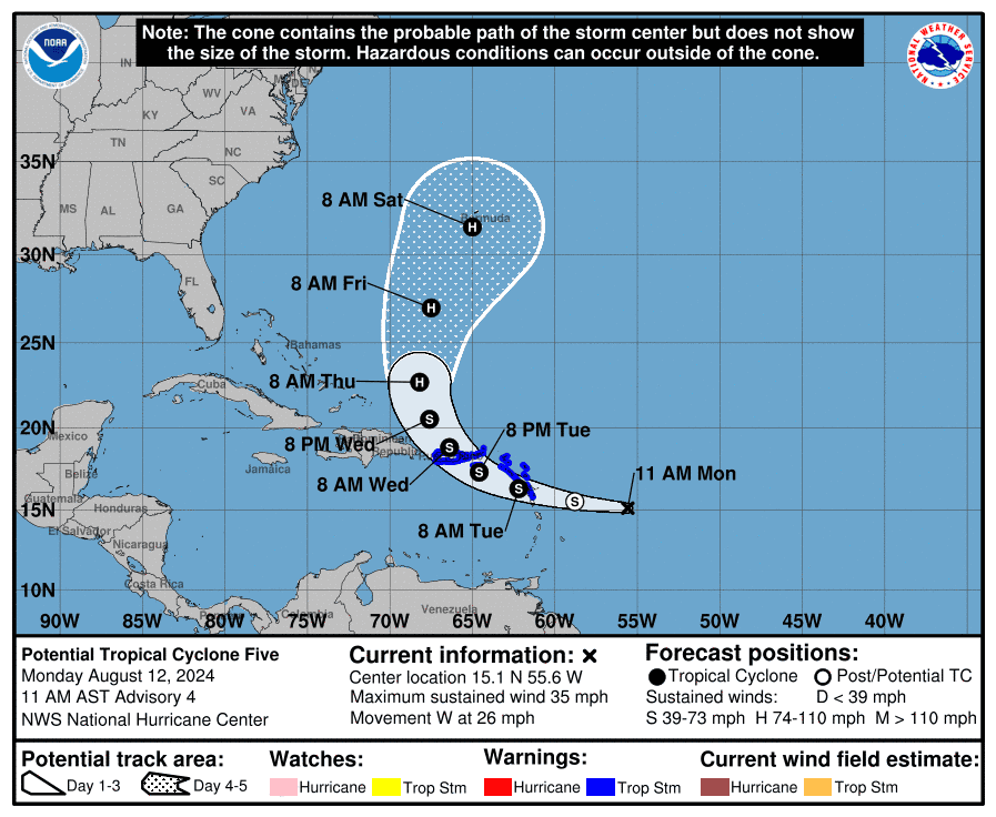
This new storm, now designated as Tropical Storm Ernesto by the National Hurricane Center.
AccuWeather meteorologists are expecting the storm to develop further, potentially becoming a major hurricane in the coming days. Its projected path will carry it across the central Atlantic Ocean, taking a general west-northwesterly track toward the Caribbean and then eyeing Bermuda.
Although the storm is expected to curve towards Bermuda, meteorologists warn that if it takes a more southern track initially, it could then push closer to the East Coast of the United States.
According to AccuWeather Meteorologist Alex DaSilva, the ocean temperatures across the Atlantic basin as a whole remain “near-record levels.” He said these heat levels can contribute to the rapid intensification of hurricanes.
AccuWeather is sticking to its forecast prior to the 2024 hurricane season, calling for a “super-charged” hurricane season and predicting that it will bring 20 to 25 named storms, 8 to 12 hurricanes, four to seven major hurricanes, and four to six direct impacts to the United States.
According to AccuWeather, as dry air diminishes and the effects of La Niña unfold this season, more storms and hurricanes are expected, and the potential energy over the very warm Atlantic waters remains high.
This article originally appeared on USATNetwork: Ernesto is barreling toward the Caribbean What we know.
