Would-be Ernesto tracked by National Hurricane Center; Puerto Rico under tropical storm watch
The National Hurricane Center is forecasting that a tropical wave east of the Lesser Antilles could hit the Leeward Islands and Puerto Rico as Tropical Storm Ernesto before growing into a Category 2 hurricane in the open ocean.
The disturbance, dubbed Potential Tropical Cyclone Five, was speeding west at a quick 26 mph early Monday, Aug. 12, with tropical storm watches and warnings painting islands from Guadeloupe to Puerto Rico, including the U.S. Virgin Islands and Vieques.
A tropical storm warning means that tropical-storm conditions are expected somewhere within the warning area within 36 hours. A tropical storm watch means that tropical-storm conditions are possible within the watch area, generally within 48 hours.
As of the NHC's 8 a.m. advisory, the system had sustained wind speeds of 30 mph and was about 525 miles east-southeast of Antigua.
While PTC Five did not have a closed center of circulation as of the NHC's 8 a.m. advisory, which can make its future track a challenge to forecast, it is expected to reach curve north on Wednesday, as an escape route is created by a a trough of low pressure moving across the U.S.
More: Colorado State University changes forecast for 2024 hurricane season in latest update
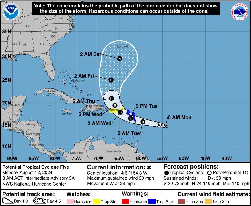
Under the official forecast path, the would-be Ernesto would gain hurricane strength north of Puerto Rico and grow to a 110-mph Cat 2 hurricane in five days as it nears Bermuda on Saturday.
"Ocean temperatures across the Atlantic basin as a whole remain near-record levels, only trailing 2023 values," said AccuWeather meteorologist and lead hurricane expert Alex DaSilva in a story posted online early Monday.
"Factors such as near-record ocean heat content levels can help to significantly contribute to the rapid intensification of hurricanes. Both Hurricane Beryl this year and Hurricane Ian in 2022 took advantage of very high sea-surface temperatures and ocean heat content, which allowed these storms to rapidly intensify as a result."
Following Ernesto, the next names on the hurricane list are Francine, Gordon and Helene.
Be prepared - 2024 Hurricane Guide:
Kimberly Miller is a journalist for The Palm Beach Post, part of the USA Today Network of Florida. She covers real estate and how growth affects South Florida's environment. Subscribe to The Dirt for a weekly real estate roundup. If you have news tips, please send them to kmiller@pbpost.com. Help support our local journalism; subscribe today.
This article originally appeared on Palm Beach Post: Tropical Storm Ernesto in Atlantic. Latest track of possible hurricane
