What to expect from Debby: A Florida city-by-city impact breakdown
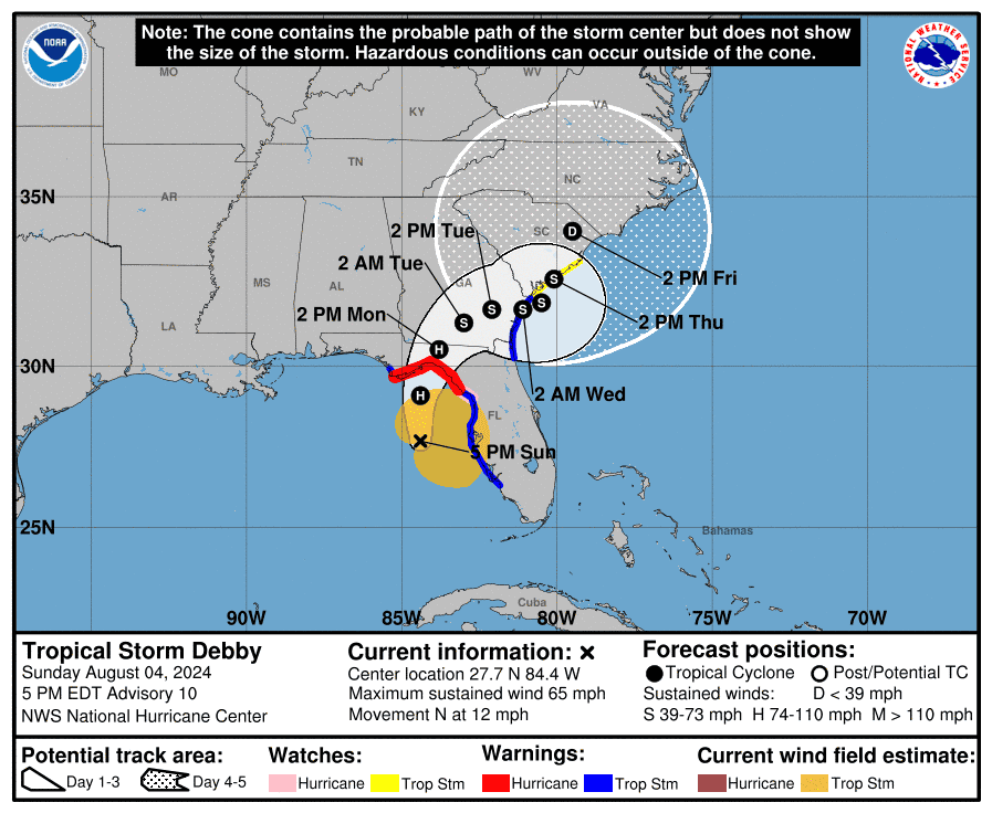
As of Sunday afternoon, Tropical Storm Debby is 12 to 16 hours from making landfall in Apalachee Bay, likely as a Category 1 hurricane.
Dangerous surge will peak Monday morning in eastern Apalachee Bay and the Nature Coast, with winds capable of snarling trees and powerlines in coastal sections of the Big Bend and possibly inland.
Debby’s track is angling a bit east today, but no matter where it makes landfall, a broad and serious flood threat will persist over northeast Florida, and eastern Georgia and the Carolinas deep into the week.
As of the NHC’s 5 p.m. advisory, Tropical Storm Debby’s maximum sustained winds remain near 65 mph, about 10 mph shy of Category 1 hurricane status.
The official NHC intensity forecast is calling for steady strengthening through landfall, with peak maximum sustained winds of 85 mph by Monday morning.
Steady rather than explosive strengthening expected as Debby contends with dry air
As of Sunday afternoon, an eye is trying to appear on radar, but dry air to Debby’s west is slowing development of a symmetrical core; there is a broad area of tropical-storm-force winds to the circulation center’s east, but none to its west.
For this reason, I continue to think strengthening into landfall will be steady rather than explosive, and a landfall intensity of 75 to 90 mph is probable.
Debby closing in on Taylor County, but a hurricane is not a point to be fixated on
Debby is now moving north at around 12 mph. As of 5 p.m., the NHC forecast track calls for continued northward movement this evening, followed by a gradual bend north-northeast overnight. The NHC track, which suggests a most likely landfall point in western Taylor County on Monday morning, may well slide a bit further east prior to landfall.
A hurricane is not a point, and impacts from Debby, especially rainfall, will extend over a large part of Florida and the Southeast for many days regardless of its exact track.
However, Debby’s surge impacts will occur near and to the east of the landfall point, with little or no surge to the west, and the strongest winds will occur in its core, which is likely to be 30 or so miles wide at landfall.
Tallahassee may again be spared the worst of a tropical threat
If you’re in Tallahassee or western Apalachee Bay, that means there is a big difference between a more westward track towards Alligator Point and a more eastward track towards Steinhatchee. West means a Hermine-like hit from the core in Tallahassee, and east brings some gusty rain, but not much else.
Observations on Sunday afternoon suggest a more eastward track in which the core of Debby passes east of Tallahassee and spares central and western Apalachee Bay destructive surge.
As Debby’s low- and mid-level centers became better stacked this afternoon, the storm slowed down, which often presages a change in direction as well. In the last few hours, Debby appears to be moving due north, or even a touch east of north.
Though we should not over-interpret short-term wobbles, the position of the steering upper-level trough is such that Debby should not move any farther west than where it is now, which is about 150 miles due south of St Marks.
Hurricane history: Tallahassee's hits and near misses since the 1800s
Hurricane Idalia retrospective: A 'meteorological sneeze' separates fortune from utter ruin
Hurricane Idalia déjà vu?
Track models for Debby have broken down along similar lines as during Idalia.
The GFS and hurricane-specific models like HAFS and HWRF have favored a Hermine-like track into western Apalachee Bay over the last few days, while the European and British models have held serve into the eastern Big Bend, with the NHC forecast consistently leaning east as well.
This afternoon’s GFS and hurricane models shifted east, but all of the GFS ensemble members are still too far west comparing their short-term forecasts to what Debby is actually doing in the real world. Expect the GFS to cave to the Euro in the end, as in Idalia.
For that reason, I’d put my money on a landfall in Taylor County, probably just northwest of Steinhatchee.
Assuming that scenario is what plays out, let’s take as specific a look as possible at Florida’s region-by-region impacts, from least to worst.
Surge, wind, rain: A Florida impact breakdown by region
Remember, these are short-term impacts through Tuesday: Debby is also likely to have a long tail of flood risks in eastern Georgia and the coastal Carolinas as it moves slowly over those areas or just offshore through Thursday or Friday.
Southeast Florida, East-central Florida, and Western Panhandle
(including Miami, Ft. Lauderdale, West Palm Beach, Melbourne, Orlando, Panama City, Destin, and Pensacola)
Debby’s impacts will be minor here. Look for periodic bands of showers today through Tuesday, more frequent in east-central Florida and the central Panhandle. Rainfall will add to up 2 inches or less, other than in the western Panhandle, which sees little precipitation due to Debby wrapping in drier air from its west.
Southwest Florida and west-central Florida
(including Tampa Bay, Naples, Fort Myers, Bradenton, and Sarasota)
Southwest Florida and Tampa Bay’s primary impact will be the 2-4 feet of storm surge that is already being felt this evening, and the heavy, continuous rainfall that has been falling since this morning.
Areas south of Tampa have already seen 2-4+ inches of rainfall in the last two days, and another 3-6+ inches is probable through Tuesday, heaviest north of Tampa.
Peak wind gusts along the coast have been in the 45-55 mph range today and these type of gusts will slowly end from south to north between late today and mid-day Monday.
Northeast Florida and coastal Georgia
(including Jacksonville, Gainesville, St. Augustine, Brunswick, and Savannah)
This area will be on Debby’s “dirty” eastern side, with rainbands increasing later tonight and heavy rainfall continuing into at least Tuesday as Debby crawls east-northeast across southeastern Georgia post-landfall.
Flooding rainfall is the major threat here, with widespread totals through early Wednesday of 6-12”, and higher local totals possible.
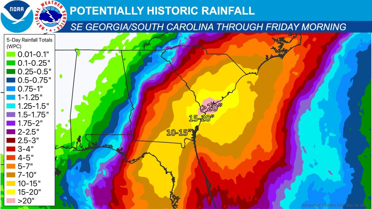
Savannah is in a rare and ominous high risk region for flash flooding in the NWS’ excessive rain outlook, and the rest of Northeast Florida and eastern Georgia is also under an elevated risk of flooding.
Offshore winds mean little or no surge threat in Florida, but coastal Georgia and South Carolina north to Charleston may see a few feet of surge by Tuesday. These areas are under a Tropical Storm Watch and Storm Surge Watch.
There is also an inland Tropical Storm Watch over portions of northeast Florida, where lower-end tropical-storm-force wind gusts of 40 to 55 mph are possible through the day on Monday.
Eastern Big Bend and Nature Coast
(including Taylor and Madison County)
This region will bear the brunt of Debby. Storm Surge Warnings are in effect for all of Apalachee Bay and Nature Coast, with life-threatening surge peaking out at 6-10 feet in eastern Apalachee Bay south to Cedar Key.
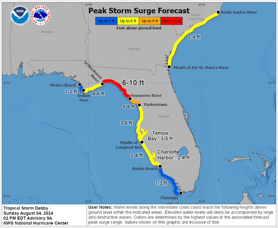
The area of highest surge danger is between Taylor County and the northern Nature Coast, where Hermine’s surge values (7.5 feet in Cedar Key) are probably a decent guide as to what to expect.
Farther south, likely surge will be 5 feet or so along the Nature Coast. The timing of overnight high tide in eastern Apalachee Bay of around 4 a.m. is not ideal, though at least it is likely to come a few hours before landfall.
The eastern Apalachee Bay coastal counties (Taylor, Dixie, and Levy) will also see the most damaging winds from Debby Monday morning, amplified by the region’s direct hit from Category 3 Idalia last August.
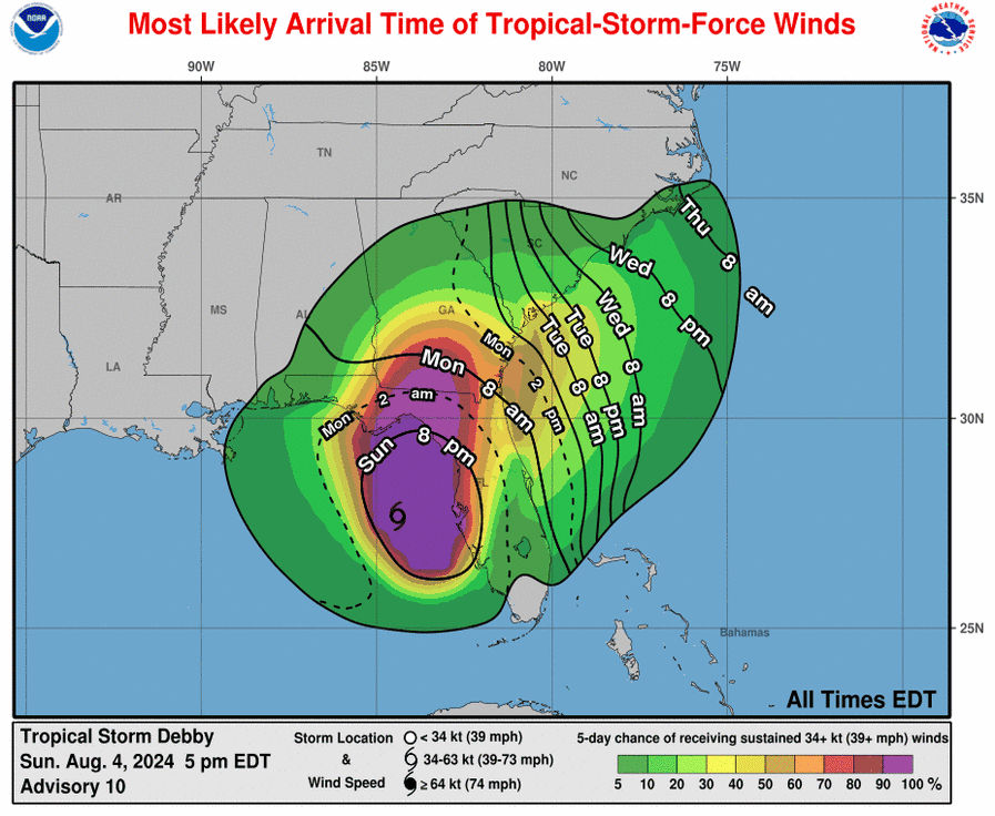
This isn’t Idalia, but hurricane-force coastal gusts are probable in eastern Apalachee Bay and the northern Nature Coast Monday morning, and moderate-to-strong tropical-storm-force gusts associated with Debby’s decaying core will likely again angle toward Madison, where inland Hurricane Warnings are in effect.
Torrential rain beginning this evening and continuing through late Monday will also cause a severe flash flooding threat across the Big Bend and northern Nature Coast.
Rain totals of 10 inches or more are expected, though Monday’s heavy rain will likely taper to intermittent showers on Tuesday, and the region should be mostly dry on Wednesday.
Western Big Bend/Eastern Panhandle
(including Tallahassee)
Finally, Florida’s Capital Region will probably (but not certainly) dodge the worst of Debby.
With the center likely to move across eastern Apalachee Bay Monday morning, surge risks west of St. Marks are falling as long as Debby doesn’t take any unexpected wobbles to the left. Otherwise, expect a sharp gradient in wind and rain impacts across the eastern Panhandle, with the precise location of that dividing line going down to the wire.
Assuming a track to Taylor County, the eastern Panhandle will see bands pushing through from the southeast for the remainder of this evening, with heavier and steadier rain associated with Debby’s outer core beginning after midnight.
These heavy outer core rains, which will have embedded wind gusts in the 40 to 50 mph range, will extend perhaps a county west of Tallahassee at their furthest extent due to Debby’s lopsided structure and impinging dry air.
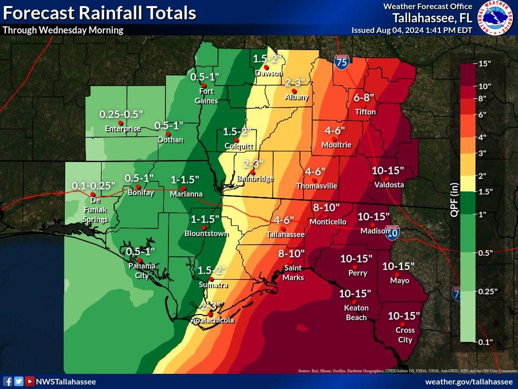
Look for the worst of the rain and wind in Tallahassee and the Capital Region mid-morning as Debby follows an Idalia-like track through the eastern Big Bend, with conditions easing to intermittent gusty showers in the afternoon. Rain totals will range from just 1-2 inches along the Apalachicola River to 6-8 inches in Monticello.
If Debby was to continue due north from its current position or make an unexpected jaunt westward, that would bump the western Big Bend into the Hermine-like 55-70 mph peak wind gust range, as well as increasing rain totals and flood risks dramatically.
I don’t expect that to happen, but will be watching closely, as the NHC track is yet another exceedingly close shave for this part of North Florida.
Finally, a major longer-range threat down the road remains the extreme rainfall totals caused by Debby’s expected slow motion over the next five days. Rain totals of 10-15+ inches from the Suwannee Valley into coastal North Carolina, create prime conditions for widespread flash flooding. These risks start Monday and continue through Friday, especially across the coastal Southeast.
Last word: Cat. 1 Debby will likely pack an outsized punch
In short, prepare for the worst and hope for the best. Debby is expected to be a Category 1 at landfall and its core will probably just miss Tallahassee to the southeast, but Category 1 hurricanes can pack an outsized punch.
Debby is very likely to pack that punch in surge terms along eastern Apalachee Bay and the Nature Coast, and in flooding terms across a swath of the Southeast U.S. this week.
Back at 9:30 p.m. with a live video forecast. In the meantime, good luck and keep watching the skies.

Dr. Ryan Truchelut is chief meteorologist at WeatherTiger, a Tallahassee company providing forensic meteorology expert witness services, and agricultural and hurricane forecasting subscriptions. Visit weathertiger.com for more information. Email Truchelut at ryan@weathertiger.com
This article originally appeared on Tallahassee Democrat: Debby does Florida: A city-by-city breakdown of impacts
