Heat to sizzle, storms to prowl as millions in US celebrate July 4th


While Independence Day is typically hot and humid with spotty thunderstorms, this year's Fourth of July may be exceptionally hot for many, AccuWeather meteorologists say. Severe storms may crash outdoor plans for some, while cool spots will be limited.
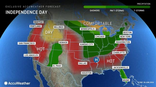
Two main zones of exceptional heat are in store for the United States, where temperatures are likely to run 5-10 degrees above the historical average. One area will extend across the Southeast states and the other will be over the western U.S., just inland of the Pacific coast.
 |
The first week of July marks the approximate six weeks of the year that typically bring the hottest conditions to most of the nation. When temperatures exceed the historical average even by a few degrees this time of the year, the heat can be dangerous.
For example, temperatures are forecast to reach the mid-90s F in Atlanta, where the average high is 90. The heat will nose farther to the north in the Eastern states with highs in the upper 80s and some zones of 90s forecast for the Interstate 95 corridor of the Northeast.
Temperatures are projected to reach the lower 90s in New York City, which is nearly 10 degrees above the historical average for July 4. Texas and other parts of the South will sizzle as well, but even with temperatures within a few degrees of the historical average over the South Central states, high humidity levels will push AccuWeather RealFeel® Temperatures to near or above 100 degrees for a time.
The most extreme heat relative to the historical average will exist over the interior West -- specifically in the zone from California's Central Valley to much of the Great Basin, west of the Rockies on Independence Day.
 |
In some locations, temperatures will climb to 10-15 degrees above the historical average. Cities such as Sacramento and Fresno, California, can expect highs well above 100. Temperatures may approach 100 in Salt Lake City.
Due to the risk of igniting wildfires, people are urged to exercise extreme caution with open flames, barbeque grills and fireworks where dry brush is extensive. Officials may declare bans on fireworks and campfires.
During an average summer day, there is almost always a risk of spotty late-day thunderstorms popping up in the hot and humid air. In situations where large numbers of people are outdoors for holiday activities, pop-up thunderstorms with sudden lightning strikes can be dangerous. However, for this Fourth of July, thunderstorms are likely to be nearly non-existent in about 75% of the nation.
 |
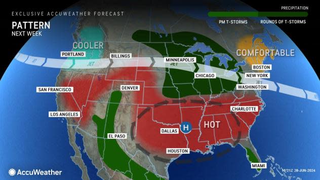
Typically, showers and thunderstorms occur more frequently in the summertime where the jet stream dips. On Independence Day, a dip in the jet stream will separate the two pockets of extreme heat over the middle of the U.S.
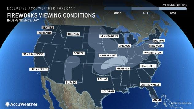
Cities that may not only be at risk for one thunderstorm but perhaps a couple of showers and thunderstorms that could interfere with outdoor plans include: Chicago, Detroit, St. Louis, Des Moines, Iowa, and Kansas City, Missouri. Locally severe thunderstorms are possible in Pittsburgh and Little Rock, Arkansas, at some point in the afternoon and evening.
This same zone in the Central states may pose some challenges for evening fireworks displays.
In most cases, thunderstorms only last an hour or so. But, a potential problem can occur when low clouds linger in the wake of showers. Light winds and moist air could lead to temporary fog formation in the evening when fireworks displays are scheduled.
 |
Mostly spotty late-day storms are anticipated for parts of New Mexico, Arizona and Colorado. People heading into the mountains to hike should be wary of rapidly building storms in the afternoon and may want to limit their activities to the morning and midday hours to reduce the risk of being struck by lightning.
Another hot spot for thunderstorm activity, although typical for July 4, will be over the Florida Peninsula. Those planning a day at the beach or golf course should closely monitor the weather for changing conditions.
As far as cool spots on the Independence Day holiday, the beaches along the Pacific coast will offer some relief from the heat, as will the beaches along the Atlantic and Gulf coasts and the thousands of lakes and streams across the nation.
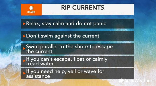
Swimmers are strongly urged to avoid wading out too far where waters are chilly, along much of the Pacific coast and New England. Rip currents always pose a risk when swimming in the ocean, even in tame sea conditions. Experts advise only swimming under the watchful eye of lifeguards.
 |
Temperate conditions are in store for the Northwest, the northern tier of the central states and northern New England. High temperatures in Seattle, International Falls, Minnesota, and Caribou, Maine, are projected to be mainly in the 70s on Thursday.
Want next-level safety, ad-free? Unlock advanced, hyperlocal severe weather alerts when you subscribe to Premium+ on the AccuWeather app. AccuWeather Alerts™ are prompted by our expert meteorologists who monitor and analyze dangerous weather risks 24/7 to keep you and your family safer.
