Hurricane to intensify over Gulf of Mexico, to be strongest to strike US this season


Key takeaways:
•A major hurricane is poised to make landfall in the United States later this week
•Helene will likely be the name given to the brewing storm
•This will be "a large storm with life-threatening impacts" hundreds of miles away from where it makes landfall
A major hurricane is coming to the Gulf of Mexico. AccuWeather meteorologists warn that communities along the central and eastern Gulf coast only have a few days to prepare for the fast-brewing, quick-moving storm, which can potentially bring life-threatening storm surge, flooding rainfall, and destructive winds.
 |
The western Caribbean to the Gulf of Mexico has been an area AccuWeather meteorologists have been highlighting as a hot spot for tropical activity since the middle of September.
Showers and thunderstorms quickly gathered over the weekend in the western Caribbean and adjacent land areas in Central America. Localized flash flooding and mudslides will occur in areas surrounding the western Caribbean from Jamaica and Cuba to southeastern Mexico, Belize, Honduras and Nicaragua.
 |
This image of the western Caribbean Sea was captured on Monday morning, Sept. 23, 2024 and shows a blossoming area of showers and thunderstorms, indicative of a developing tropical cyclone. (AccuWeather Enhanced RealVue™ Satellite) |
AccuWeather began designating the brewing system as a tropical rainstorm this past weekend to raise public awareness and issue its own track map to help people and officials plan ahead. On Monday morning, the National Hurricane Center (NHC) issued an advisory for Potential Tropical Cyclone 9. When it is upgraded to a tropical storm with sustained winds of at least 39 mph, it will be given a name.
The next name on the list is Helene.
"The combination of deep warm water (ocean heat content) and low disruptive breezes (wind shear), should assist in rapid strengthening when over the Gulf of Mexico from Wednesday to Thursday," AccuWeather Chief On-Air Meteorologist Bernie Rayno said.
"Most likely, the storm will create its own environment and bring a surge in moisture to the currently dry air over the Gulf," Rayno added.
AccuWeather is expecting the storm to make landfall as a major hurricane of Category 3 strength (111-129 mph) on the Saffir-Simpson Hurricane Wind Scale. However, it could reach Category 4 status (130-156 mph) at some point while it is over the Gulf of Mexico.
 |
At this time, the storm's eye is most likely to track along the Gulf coast from the eastern tip of Louisiana to the central part of the Florida Peninsula.
The highest landfall probability at this time is somewhere along the coast of the Florida Panhandle late Thursday. A track into the Florida Peninsula could mean an earlier landfall Thursday.
However, people should not just focus on where the eye could make landfall.
"This can be a large storm with life-threatening impacts such as storm surge and flooding rain hundreds of miles away from where the storm makes landfall - be sure to know the risks you can face in your community," AccuWeather Chief Meteorologist Jonathan Porter said.
 |
There is a significant risk to lives and property with the upcoming hurricane in the U.S.
The current rainstorm, soon to become a major hurricane, is initially rated as a 3 on the AccuWeather RealImpact™ Scale for Hurricanes. This scale incorporates much more than the Saffir-Simpson scale, which is based on wind intensity alone.
The RealImpact scale weighs in storm surge, flooding rain, economic loss and population affected in addition to damaging wind gusts and tornadoes produced by a tropical system. It is possible the RealImpact may be pushed higher.
 |
Wind gusts frequenting 100-140 mph are forecast near where the storm lands, with an AccuWeather Local StormMax™ wind gust of 160 mph.
Widespread power outages are anticipated near north and east of where the eye makes landfall.
 |
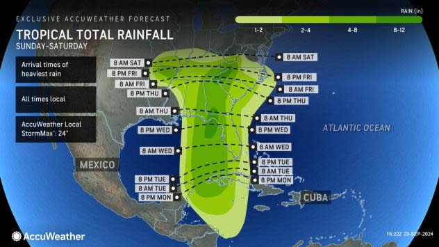
Near where the hurricane makes landfall, general rainfall of 8-12 inches is forecast, with an AccuWeather Local StormMax™ rainfall of 24 inches. A pocket of 8-12 inches of rain is also likely in the southern Appalachians and Piedmont.
Even as the storm loses wind intensity after moving well inland, the likelihood of heavy rain will continue. Typically in the hours and days after landfall, the heaviest rain shifts to the north and west of the storm center.
"There is the risk for major flooding in parts of the Southeast late Thursday into Friday, including the Atlanta area as well as the steep terrain of the southern Appalachians, where the flooding risk can be especially elevated as well as the risk for mudslides and rockslides," Porter said.
 |
Some of the heaviest rainfall hundreds of miles from the Gulf Coast may steer across the Tennessee, lower Ohio and mid-Mississippi valleys. Flooding along some of the secondary rivers is possible, but a moderate rise on the Ohio and Mississippi rivers would be welcomed by tug and barge operations that cost-effectively transport goods. Low water levels for the third year in a row have been restricting these operations.
Heavy rain may fall as far to the west as part of the Ozark Mountains in Missouri and Arkansas late this week.
Even if the storm steers northwestward for a time after landfall, a zone of heavy rain will break out farther to the east as a plume of moisture streams in from the Atlantic along the Georgia and South Carolina coasts.
Prior to the upcoming major hurricane strike, the strongest storm to make landfall in the U.S. was Francine as a Category 2 on the Saffir-Simpson scale. Francine struck the Louisiana coast during the late afternoon hours of Sept. 11.
Want next-level safety, ad-free? Unlock advanced, hyperlocal severe weather alerts when you subscribe to Premium+ on the AccuWeather app. AccuWeather Alerts™ are prompted by our expert meteorologists who monitor and analyze dangerous weather risks 24/7 to keep you and your family safer.
