Invest 92L could become tropical depression before reaching Florida, Georgia coast
Tropical Storm Alberto quickly weakened after making landfall near sunrise in Mexico Thursday morning. By 11 a.m., it had been designated as a tropical depression.
Elsewhere, the National Hurricane Center also is keeping a close eye on two other tropical disturbances.
A system east of Florida — now identified as Invest 92L — has a medium chance for development and could become a tropical depression before it approaches the coast of Northeast Florida or Georgia early Friday, according to the latest advisory from the National Hurricane Center.
➤ Live from USA Today: Alberto bears down on Texas
Gusty winds and locally heavy rainfall are possible Friday, according to the National Weather Service Jacksonville.
"Bands of breezy to windy showers and isolated storms are expected (from Invest 92L), especially north of Cape Canaveral Thursday night to early Friday," the National Weather Service Melbourne said.
There's also a high risk of life-threatening rip currents with large breaking waves at all Central Florida Atlantic beaches, the National Weather Service Melbourne said, suggesting beachgoers should remain out of the water.
➤ WeatherTiger on Invest 92L: Impacts on Florida will be little different than a typical day in June
"Regardless of development, this feature can bring high seas, gusty winds and areas of heavy rain and thunderstorms to the Southeast coast," said AccuWeather Meteorologist Andrew Kienzle.
Another system with a much stronger chance for development is following a path similar to Tropical Storm Alberto. It could become a tropical depression over the weekend, according to the National Hurricane Center.
The next named storm of the 2024 Atlantic hurricane season will be Beryl.
Here's the latest update from the NHC as of 8 a.m., June 20:
Tropical Storm Alberto makes landfall in Mexico
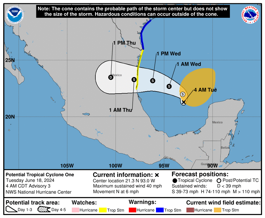
Special note on the NHC cone: The forecast track shows the most likely path of the center of the storm. It does not illustrate the full width of the storm or its impacts, and the center of the storm is likely to travel outside the cone up to 33% of the time.
As of 11 a.m.:
Location: 280 miles south-southwest of Brownsville, Texas
Maximum wind speed: 35 mph
Direction: west at 18 mph
➤ Read more about Tropical Depression Alberto
Spaghetti models for Tropical Depression Alberto
➤ Track Tropical Depression Alberto
Special note about spaghetti models: Illustrations include an array of forecast tools and models, and not all are created equal. The hurricane center uses only the top four or five highest performing models to help make its forecasts.
What is out there and how likely are they to strengthen?
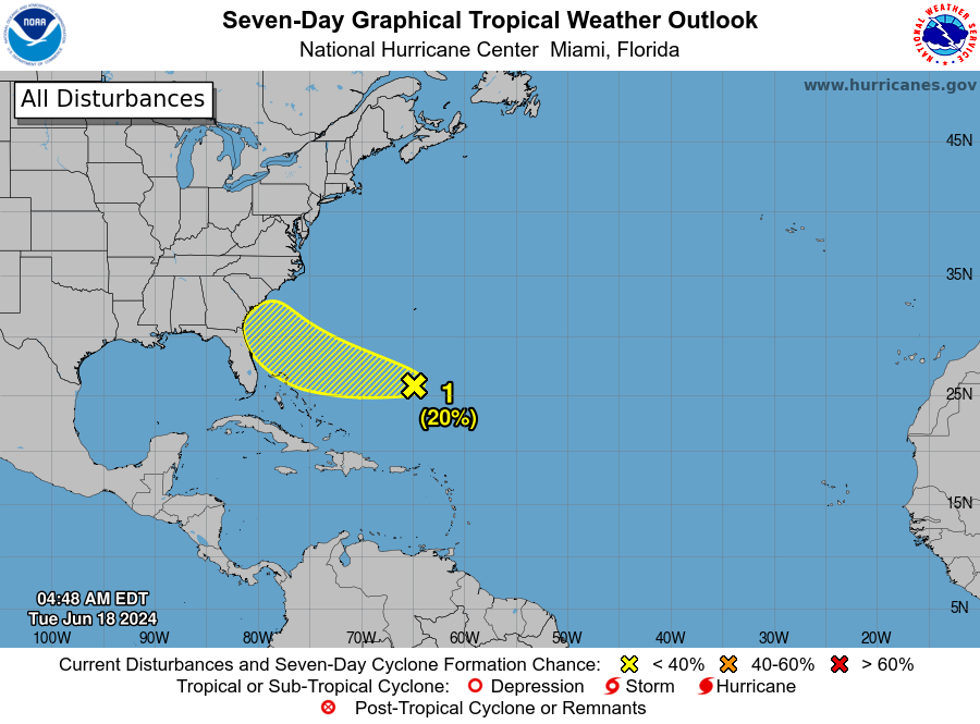
Invest 92L: A small area of low pressure located about 150 miles east of the northernmost Bahamas continues to produce disorganized showers and thunderstorms.
While environmental conditions are only marginally conducive due to nearby dry air, further development of this system could lead to the development of a tropical depression while the low moves west-northwest at 10 to 15 mph and approaches the northeastern coast of Florida or the Georgia coast early on Friday.
92L impact on Florida: Invest 92L approaching Florida, Georgia. Track system, see possible impacts
An Air Force Reserve reconnaissance aircraft is scheduled to investigate this system this afternoon, if necessary.
Formation chance through 48 hours: medium, 40 percent.
Formation chance through 7 days: medium, 40 percent.
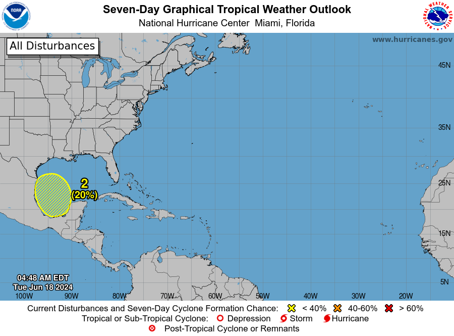
Southwestern Gulf of Mexico: A broad area of low pressure is forecast to form over southeastern Mexico and northern Central America on Friday.
Environmental conditions appear conducive for gradual development after this system moves over the Bay of Campeche on Saturday, and a tropical depression could form over the southwestern Gulf of Mexico thisweekend while it moves slowly west-northwest or northwest.
Formation chance through 48 hours: low, low 20 percent.
Formation chance through 7 days: medium, 50 percent.
Who is likely to be impacted?
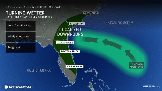
Invest 92L: "Regardless of development, this feature can bring high seas, gusty winds and areas of heavy rain and thunderstorms to the Southeast coast," said Kienzle.
From late Thursday to Saturday, 1-2 inches of rain can generally fall along the Southeast coastal regions, particularly across southeastern Georgia.
Southwestern Gulf of Mexico: This system could become a tropical depression over the southwestern Gulf of Mexico over the weekend as it moves slowly west-northwest or northwest, according to the National Hurricane Center.
"There is a moderate chance for development from June 21-23 across a similar area in the Gulf of Mexico," according to AccuWeather.
"This feature will need to be watched for possible impacts on the Gulf coasts of the United States and Mexico this weekend into early next week," Kienzle said.
Forecasters urge all residents to continue monitoring the tropics and to always be prepared. That advice is particularly important for what is expected to be a very active hurricane season.
Weather watches and warnings issued in Florida
When is the Atlantic hurricane season?
The Atlantic hurricane season runs from June 1 through Nov. 30.
When is the peak of hurricane season?
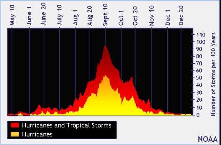
The peak of the season is Sept. 10, with the most activity happening between mid-August and mid-October, according to the Hurricane Center.
National Hurricane Center map: What are forecasters watching now?
Systems currently being monitored by the National Hurricane Center include:

Interactive map: Hurricanes, tropical storms that have passed near your city
Excessive rainfall forecast
What's next?
We will continue to update our tropical weather coverage daily. Download your local site's app to ensure you're always connected to the news. And look for our special subscription offers here.
This article originally appeared on Treasure Coast Newspapers: NHC tracking Invest 92L, tropical disturbance. Florida, Texas impacts
