Jova becomes Western Hemisphere's strongest hurricane so far in 2023 ... for now

Hurricane Jova, churning west across the open Pacific Ocean, strengthened into a major Category 5 hurricane for a time from Wednesday evening into Thursday morning in the Eastern Pacific. However, the storm poses no immediate threat to land, AccuWeather hurricane experts say.
The powerhouse hurricane, the first to achieve Category 5 status on the Saffir-Simpson Hurricane Wind Scale (SSHWS) in the basin since there were three such storms in 2018, may soon have company in the Atlantic, as Hurricane Lee strengthens into this weekend. AccuWeather, however, does not expect both hurricanes to be at their peak strength at the same time.
A Category 5 hurricane on the SSHWS is one with maximum sustained winds of at least 157 mph (252 km/h), the highest category on the scale.
 |
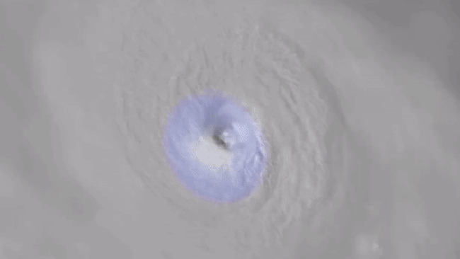
Hurricane Jova swirls in the eastern Pacific Ocean on infrared satellite on the morning of Sept. 7, 2023. |
As of Friday morning, local time, Jova (pronounced HO-vah) was centered about 550 miles to the southwest of the southern tip of Baja California, Mexico, and was moving away from the country, to the west-northwest at 16 mph.
"Jova will track to the northwest through the weekend and is not expected to bring direct impacts to land," AccuWeather Meteorologist Brandon Buckingham said. "It will, however, bring rough surf and rip currents to the west coast of Mexico and potentially into coastal Southern California."
Packing maximum sustained winds of 155 mph (249 km/h), Jova was a Category 4 hurricane, down from peak intensity at Category 5 status with 160 mph (257 km/h) winds from Wednesday evening into early Thursday morning. A gradual loss of wind intensity is expected to continue through Friday and the weekend, as Jova moves over colder waters in the open Pacific, AccuWeather forecasters say.
Have the app? Unlock AccuWeather Alerts™ with Premium+
While the loss of wind intensity for Jova will be slow to occur, its ramp-up to Category 5 status on Wednesday happened at a tremendously fast rate. When the day began, Jova had just become a hurricane, with 85-mph (137 km/h) winds; by the time the day was over, it was already a Category 5 storm, with 160-mph winds.
The pace of increase in Jova's wind intensity was more than double the National Hurricane Center's official definition for rapid strengthening, which is an increase of 35 mph over a 24-hour period. Over just an 18-hour period on Wednesday, Jova gained 75 mph of wind intensity. The storm's minimum central pressure also fell by 1.89 inches of mercury (64 millibars) in a 24-hour period, also indicative of explosive strengthening.
 |
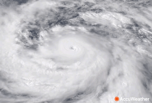
Hurricane Jova swirls in the eastern Pacific Ocean on AccuWeather RealVue (tm) satellite on the evening of Sept. 6, 2023. |
As of Thursday morning, Jova exhibited a symmetrical "buzzsaw" shape and a clear eye on satellite imagery, cementing its status as the strongest storm the Western Hemisphere has seen so far in 2023.
With AccuWeather forecasting Hurricane Lee in the Atlantic Ocean to become a Category 5 hurricane soon as well, a question has arisen: Have there ever been two concurrent hurricanes at peak scale intensity in both basins? The answer is no -- at least not since reliable records began earlier last century.
As Jova slowly continues to lose wind intensity late this week and Lee gains it into this weekend, it appears that the milestone of Category 5 hurricanes churning across both basins at the same time will be missed again.
This year, however, would become only the second on record where each basin records at least one Category 5 hurricane, if Lee achieves that status this weekend, as forecast by AccuWeather. The last time that occurred was in 2018 when Lane, Walk and Willa roamed the Pacific and Michael churned in the Gulf of Mexico.
 |
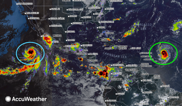
Hurricanes Jova (blue circle) and Lee (green circle), as seen on AccuWeather RealVue™ Enhanced Satellite on Thursday morning, Sep. 7, 2023. |
It is possible that prior to the 1960s multiple Category 5 hurricanes roamed each ocean at the same time, but it is impossible to know for sure since the first weather satellite, TRIOS, was not launched until 1960.
Jova also became the first Category 5 hurricane in the Eastern Pacific since Willa achieved that status on Oct. 22, 2018.
The last Category 5 hurricane in the Atlantic occurred just last year (Ian on Sept. 28).
Want next-level safety, ad-free? Unlock advanced, hyperlocal severe weather alerts when you subscribe to Premium+ on the AccuWeather app. AccuWeather Alerts™ are prompted by our expert meteorologists who monitor and analyze dangerous weather risks 24/7 to keep you and your family safer.
