Last gasp of monsoon to accompany wild weather in southwestern US


 |
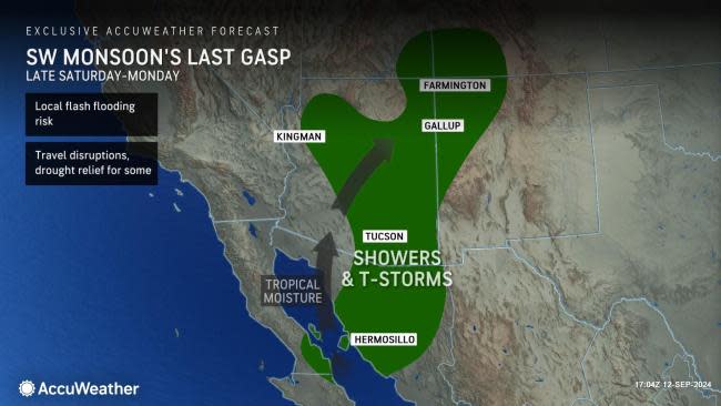
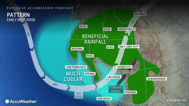
A tropical storm, the North American monsoon and the jet stream will team up to bring a wide range of weather conditions to the southwestern United States, including flooding downpours, severe thunderstorms, strong winds and a big push of chilly air that can produce some snow from this weekend into early next week, AccuWeather meteorologists say.
Eastern Pacific Tropical Storm Ileana, will lose wind intensity as it moves onshore in western Mexico this weekend, but as a tropical rainstorm it will pump moisture into part of the southwestern U.S.
 |
An example of such a tropical rainstorm was Hilary from 2023. Hilary was initially a powerful Category 4 hurricane over the eastern Pacific. By the time it reached the U.S. as a tropical rainstorm, it continued to produce torrential rain and trigger flooding over California and parts of the interior Southwest for days.
The tropical moisture moving ashore late this week will become intertwined with the ongoing North American monsoon, boosting the intensity and coverage of the spotty thunderstorm activity, AccuWeather Senior Meteorologist Dave Houk said.
The North American monsoon is the annual shift of prevailing breezes in the southwestern U.S. that helps to transport moisture northward from the Gulf of Mexico and the eastern Pacific.
"Thunderstorm activity will increase in southern Arizona on Saturday afternoon and may reach into the Phoenix area by Saturday night," Houk explained, "And, as the tropical flow of moisture increases from Sunday to Monday, ahead of a big dip in the jet stream, drenching showers and locally gusty thunderstorms will expand in coverage over Arizona and spread into New Mexico."
 |
While rainfall in most of the interior Southwest will generally be under an inch from Saturday to Monday, some of the rainiest spots may receive 3-4 inches of rain and a higher risk of flash flooding and debris flows. Some of the Arizona cities at risk for flash flooding include Phoenix, Tuscon and Flagstaff, with the potential for the same in Gallup, New Mexico, and Durango, Colorado.
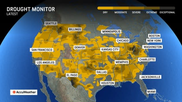
Aside from the dangers created by torrential downpours, any non-flooding rainfall would help to ease drought problems.
 |
The same big dip in the jet stream will kick up south-to-southwesterly winds over much of the region from Sunday to Monday. The strength of the wind may not be the only problem for trucks and other high-profile vehicles, but dust storms can occur where little or no rain falls.
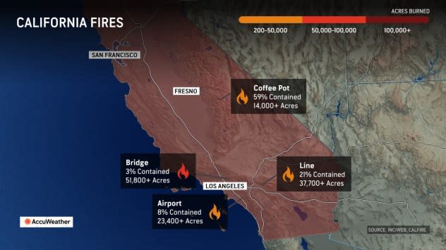
A higher-level concern will be the potential to fan the flames of existing wildfires or trigger new fires where sparks from utility lines or power equipment occur. Any wildfire could move rapidly with winds that may average 15-30 mph with much higher gusts.
 |
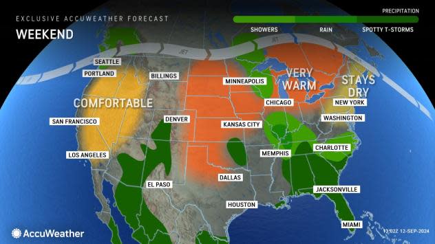
The jet stream dip will usher much cooler air into the Southwest, with most valleys and low-elevation areas along the coast experiencing a temperature drop between 10-15 degrees Fahrenheit from this weekend to early next week.
For example, the Palm Springs, California, area can expect highs near 100 this weekend, but highs early next week will be mainly in the upper 80s to near 90 early next week. Highs in Las Vegas will be in the mid- to upper 90s this weekend and will be swapped with highs in the mid-80s on Monday and Tuesday and then the low 80s by Wednesday.
 |
In the mountains, the cool sweep will be more dramatic. Highs in the 70s on Saturday will be swapped with highs in the low 50s by Monday around Lake Tahoe, California.
"The air will get chilly enough to allow some snow to fall over the northern and central Sierra Nevada, and the ground can be covered in spots over Donner Pass, California, from later Sunday night to Monday," Houk said.
The same pattern will bring showers to some of the lower elevations in Central California as well. Both San Francisco and Sacramento received a bit of rain in late August; the setup could bring a few hundredths to a couple of tenths of an inch of rain in some cases from Sunday night to Monday.
 |
"It is not uncommon for a tropical [feature] such as the one to be in the vicinity early next week to initiate a significant pattern change to the Southwest, including an end to the North American monsoon," Houk said.
In the wake of Ileana and the jet stream dip that follows, winds will be more westerly across the Southwest region moving forward into the fall, which should result in a periodic downward trend in temperatures. The pattern will mean little to no monsoon-based thunderstorm activity but may allow enough moisture from the Pacific to bring some sporadic rain events to parts of California.
Want next-level safety, ad-free? Unlock advanced, hyperlocal severe weather alerts when you subscribe to Premium+ on the AccuWeather app. AccuWeather Alerts™ are prompted by our expert meteorologists who monitor and analyze dangerous weather risks 24/7 to keep you and your family safer.
