Stage set for tropical development in south-central Atlantic and Caribbean

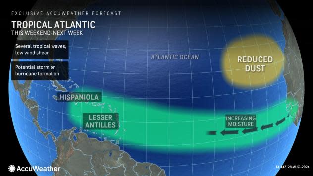


The Atlantic has been asleep since Ernesto dissipated a week ago, but a resurgence of moisture from Africa that began earlier this week may be a sign of a coming pulse of tropical activity with one feature on AccuWeather meteorologists' radar starting this weekend as it nears the Caribbean.
Despite expected lulls in tropical activity during July and August, the busiest part of the hurricane season is at the doorstep. Quiet conditions can quickly evolve into a busy time in the tropics. With changes slowly evolving into next week, tropical storms and hurricanes may be about to break loose or at least wake up.
 |
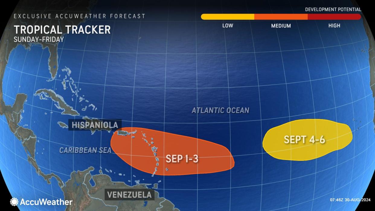
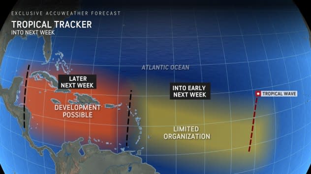
"One area being watched closely into next week extends from the south-central Atlantic to near the Windward Islands and has been increased from low to a moderate risk for development," AccuWeather Lead Hurricane Expert Alex DaSilva said.
 |
"Piecing together a strong increase in moisture, lowering wind shear, lowering dust levels and anticipated rising air, there are signs of an uptick in tropical development coming soon for south-central Atlantic and the Caribbean," DaSilva said, "Waters that cooled in the wake of Ernesto in the south-central Atlantic are warming now as well, which is another positive for development."
"Wind shear may still be a bit too strong until the system travels farther to the west and possibly gets into the Caribbean," AccuWeather Chief On-Air Meteorologist Bernie Rayno added.
How soon the feature takes shape, if it develops, may determine where it will track. The feature could curve northward or continue on to the west.
A tropical wave that evolves quickly is more likely to turn northwestward sooner and possibly track near the northern islands of the Caribbean. A system that remains weak may continue westward longer and may get into the central and western Caribbean rather than turn up east of Florida.
"Waters are plenty warm, moisture is present and wind shear is low if the system gets into the open waters of the Caribbean," Rayno stated, "If the feature gets in there, there is a really good chance of it developing."
 |
As the tropical wave approaches the Windward and Leeward Islands Sunday night and Monday, locally drenching showers, gusty thunderstorms and rough seas are possible, depending on the intensity and organization of the feature.
The area from Puerto Rico to Hispaniola may be affected by similar conditions from Tuesday to Wednesday, depending on size, intensity and organization.
"We are also watching for a surge of moisture that moves up from the Caribbean and into the Gulf this weekend to early next week, which could evolve into something to track and raise impacts," DaSilva said.
The key is as vast areas of dry air and high wind shear are replaced with moisture and low wind shear, there are bound to be multiple tropical development risks that unfold moving forward through September.
Some of the key factors that AccuWeather meteorologists consider when forecasting tropical activity include moisture in the air, wind shear, and waves of low pressure that move westward across the Atlantic from Africa.
Wind shear measures breezes across the sea surface and well above it. When these breezes are strong from one direction or changing directions, they can deter tropical development. Low wind shear creates favorable conditions for tropical systems to develop.
Oceanic temperature fluctuations and changes in the amount of rising versus sinking air also impact tropical development. Cool pockets of water (below 78 F) can inhibit development. Rising air promotes development as it allows for robust thunderstorm activity.
AccuWeather meteorologists track a phenomenon known as the Madden-Julian Oscillation. In highly simplified terms, this slow-moving wave of rising air-like a crowd wave in a football stadium-moves from west to east around the globe. It takes 30-60 days for the wave to complete its cycle around the entire globe in the Tropics.
"The wave of rising air associated with the Madden-Julian Oscillation should reach the Atlantic basin during week one or two of September," AccuWeather Lead Long-Range Meteorologist Paul Pastelok said, "We could then see a surge of tropical activity in the Atlantic."
Looking farther ahead, as long as dry air and wind shear do not surge again over the tropical Atlantic, many more systems could follow the features being monitored in the next week. Hurricane season officially runs from June 1 through Nov. 30. From a historical standpoint, the busiest part of the hurricane season extends from September to October, with the second half being the busiest.
 |
AccuWeather maintains its stance on a super-charged hurricane season for 2024 with the current number of systems that have developed still on par with the historical average and the busiest part of the season just ahead.
"In a new development, AccuWeather hurricane experts now assess that 20-23 named storms are more likely than 20-25. This adjustment is fewer named storms than many other sources are predicting," explained AccuWeather Chief Meteorologist Jon Porter. "The reason for this assessment is the long lull that has occurred in recent weeks when there have been no named storms during what is typically an increasingly active part of the hurricane season."
The 2024 season has already seen the earliest-forming 165-mph Category 5 hurricane on record: Beryl. The "B" storm was also the strongest hurricane on record for July.
Want next-level safety, ad-free? Unlock advanced, hyperlocal severe weather alerts when you subscribe to Premium+ on the AccuWeather app. AccuWeather Alerts™ are prompted by our expert meteorologists who monitor and analyze dangerous weather risks 24/7 to keep you and your family safer.
