Storm tracker: National Hurricane Center tracking 3 tropical disturbances in Atlantic
Editor's Note: This page is a summary of news on tropical systems for Saturday, Aug. 31. For the latest on the possibility of new Atlantic storms view our story for Sunday, Sept. 1.
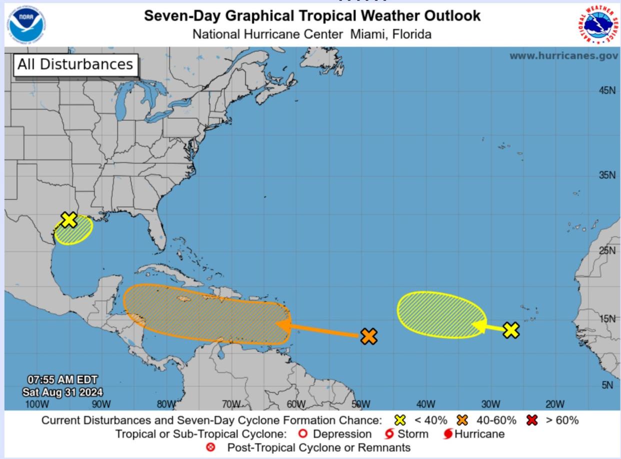
The National Hurricane Center is tracking three separate tropical disturbances in the Atlantic Ocean, but the Labor Day weekend looks to be calm in the tropics.
However, one of the systems – a tropical wave east of the Lesser Antilles – could become a tropical depression in the middle to later part of next week as it moves westward, the center said at 8 a.m. ET Saturday. The system is expected to reach the Lesser Antilles on Monday and continue moving across the Caribbean Sea.
The hurricane center gives the system a 50% chance of developing over the next seven days.
Labor Day weekend weather: Thunderstorms and a heat wave could upend holiday weekend plans
Atlantic Storm Tracker
National Hurricane Center: Tracking two more systems in the Atlantic
Two other systems have a low chance of developing over the next 48 hours, the NHC says.
Northwestern Gulf of Mexico: A broad low pressure system in the northwestern Gulf of Mexico near the upper Texas coast is bringing rain and thunderstorms along and off the coasts of Texas and Louisiana. The "tropical rainstorm" may bring "heavy rain, possible flooding and perhaps locally gusty winds in parts of Texas and Louisiana," Accuweather senior meteorologist Alex Sosnowski noted Saturday. The rainstorm could become a tropical depression near the Gulf Coast, he wrote. The NHC gave the system's chance of development over the next seven days as 20%.
Eastern Tropical Atlantic: The second disturbance, a tropical wave, is currently in the Eastern Tropical Atlantic, just west of the Cabo Verde Islands, which lie off the west coast of Africa. "Development, if any, should be slow to occur while the system moves slowly westward to west-northwestward over the eastern and central tropical Atlantic through late next week," NHC forecasters said Saturday. Chance of development over the next seven days: 10%.
Could September bring a busy Atlantic hurricane season?
The hurricane center is currently tracking three tropical systems for signs they could develop into stronger storms.
Activity in the Gulf of Mexico could increase because water temperatures are at record levels, which can lead to the development of storms and hurricanes. "If anything develops in the Gulf, it could take off very quickly. People have to pay attention: Storms can rapidly evolve and intensify rapidly," AccuWeather hurricane expert Alex DaSilva told USA TODAY Wednesday.
Also, in the Atlantic, dry, dusty air from Africa that has prevented storms from developing is forecast to wane, DaSilva said. "The dust will go away, and allow for the Atlantic to wake up," he said.
Contributing: Doyle Rice, Gabe Hauari, and Jennifer Sangalang, USA TODAY Network.
Follow Mike Snider on X and Threads: @mikesnider & mikegsnider.
What's everyone talking about? Sign up for our trending newsletter to get the latest news of the day
This article originally appeared on USA TODAY: Storm tracker: National Hurricane Center tracking 3 Atlantic systems
