Another bomb cyclone brewing as part of West Coast storm train


A powerful bomb cyclone that reached maximum intensity over the northern Pacific Thursday afternoon marked the beginning of an intense and stormy stretch for the West Coast. That storm will continue to send additional storms into the region through next Tuesday, unleashing nearly 2 feet of rain in some areas and up to 8 feet of snow over the mountains. Even though the precipitation is much needed across the drought-stricken region, it could lead to serious flooding, mudslides and significant threats to lives and property.
But the storm won't be all bad news.
"This rainfall is coming about a month ahead of average and will be very welcome in fighting the remaining fires, particularly in Northern California," AccuWeather Chief Meteorologist Jon Porter said. "Repeated storms delivering such copious rainfall will have a major effect on the wildfire season - effectively ending the wildfire season from Northern California northward," Porter added.
Wildfires have burned 1.9 million acres in California in 2021, according to the National Interagency Fire Center. Eight out of the 17 massive fires burning in the United States were all raging in California, as of Thursday.
On the other hand, rainfall will come "too fast and too furious" in some areas with rates of up to 2 inches an hour, according to Porter. The excessive rainfall could result in flash flooding and other dangers like mudslides, particularly in burn scar areas from wildfires that charred the ground in recent years.
Satellite images showed the first storm spinning over the northern Pacific -- taking on an almost hurricane-like appearance -- just off the coast of western Canada and the Northwest on Thursday. The storm's central atmospheric pressure plummeted to 28.08 inches of mercury (951 millibars) Thursday afternoon - down from 29.12 inches of mercury (986 millibars) on Wednesday and enough to meet the official criteria for bombogenesis, which occurs when a storm's central pressure drops by at least 0.71 of an inch of mercury (24 millibars) within 24 hours.
Its central pressure dropped to lower than that of Hurricane Larry, which was a Category 3 storm over the Atlantic early in September and packed sustained winds up to 125 mph. Larry's lowest central pressure was 28.20 inches of mercury (955 millibars).
Around noon Thursday local time, data from Environment Canada began to give an idea of the storm's power. Wind gusts up to 100 mph were reported at Solander Island. Thursday Night, additional wind gusts were reported to 75 mph at several locations on the coast of British Columbia, with waves as high as 35 feet reported offshore.
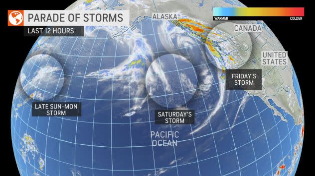
On Friday, a wide satellite view provided a stark visual of what's in store for the West Coast over the next several days. Additional storms have lined up over the northern Pacific Ocean are headed for the western U.S. and will each bring varying degrees of intensity and impacts, but the cumulative effects of the storms will be dramatic.
 |
The bomb cyclone was only the first of the three storms forecast to impact the U.S. West Coast through the last Tuesday of October, according to AccuWeather Chief On-Air Meteorologist Bernie Rayno.
While most of the first storm's fury has subsided along the Pacific coast from British Columbia to Northern California, the storm managed to unload a general 1-3 inches of rain on the region with local amounts to 4 and 5 inches in coastal Northern California. Mount Tamalpais, California, picked up more than 6 inches of rain from the storm through Thursday night.
As the risk of mudslides continues in the wake of the first storm, due to now wet and unstable soil, only a little breather is in store as the second and weakest storm of the series moves in to start the weekend with only light to moderate rainfall.
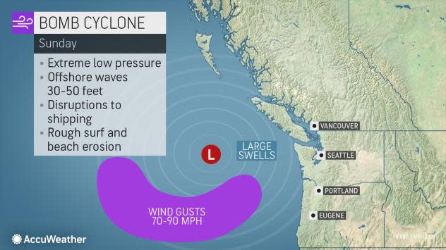
Forecasters warn that the storm that follows on Sunday is likely to be the strongest of the entire storm train and will undergo rapid intensification as another bomb cyclone. Since this second bomb cyclone is likely to form and travel farther south than the prior storms of this past week, it is expected to bring heavier precipitation and stronger winds along the West Coast - and it will pull in deep tropical moisture from the Pacific, creating what meteorologists refer to as an atmospheric river.
CLICK HERE FOR THE FREE ACCUWEATHER APP
 |
An atmospheric river is almost like a firehose of moisture in the sky and is capable of unleashing intense rain and mountain snow. Moisture from the developing atmospheric river is expected to take aim at the northern and central portions of California as well as part of southern Oregon with the greatest intensity from Sunday morning to Monday.
During that time frame, rain can pour down at the rate of 1-2 inches per hour for a time over several hours and could lead to rapid runoff over the steep terrain that faces the ocean. A total of 4-8 inches of rain is predicted in Northern and Central California with an AccuWeather Local StormMax™ of 16 inches from Sunday to Tuesday.
 |
The storm hitting from Sunday into Tuesday will bring heavy rain to San Francisco and Sacramento as well. Both of these cities will pick up between 2 and 4 inches of rain with the potential for even greater amounts. Urban flooding is almost a certainty.
On top of the excessive rainfall, strong winds associated with the second bomb cyclone, which could be stronger than the first, will blast the coast of Northern and Central California and southern Oregon from Sunday into Monday. In this zone, wind gusts will average 40-60 mph with AccuWeather Local StormMax™ gusts to 80 mph. At this force, some tree and property damage can occur, and sporadic to regional power outages are likely.
The train of storms is likely to wallop Northern California and southern Oregon with 8-16 inches of rain through Tuesday. An AccuWeather Local StormMax™ of 20 inches is predicted in those areas.
A key player in how far south the moisture reaches -- and when -- will be the positioning of the jet stream. "With each storm through Tuesday," Rayno said, "the jet stream will shift progressively farther south, and that means the moisture with each storm will follow suit." Rainfall is forecast to reach Southern California by early next week.
 |
A general 0.50 of an inch to 1 inch of rain is forecast to fall as far south as Los Angeles and San Diego from Monday into early Tuesday. Locally higher amounts of 1-3 inches are expected over the mountains to the north and east of Los Angeles and east of San Diego. Downtown Los Angeles has only received 0.40 of an inch of rain since the start of the new rain season on July 1. The average rainfall for all of October is only 0.33 of an inch for Los Angeles and 0.29 of an inch for San Diego. Locally soaking showers may even reach the deserts of Southern California and southern Nevada.
And in addition to unleashing much-needed rain, the storms will bring tremendous amounts of snow to the mountains. As colder air arrives with the bigger storm Sunday to Tuesday, snow will begin to fall at elevations above 8,000 feet -- and it is this storm that is expected to unload the majority of snowfall over the Sierra Nevada.
 |
"Given the amount of moisture aiming at the northern and central Sierra Nevada, there can easily be 60 to 100 inches of snow at levels above 8,000 feet," AccuWeather Senior Storm Warning Meteorologist Rich Putnam said. That translates to a prolific 5-8 feet of snow or around 2 yards of snow at the ski resorts in the Sierra Nevada.
The heavily traveled Donner Pass along I-80 in California, about 40 miles west of Reno, Nevada, will see a changeover to snow late Sunday night, and heavy snow will continue to fall through Monday night. There is the potential for 1-2 feet of snow and locally higher amounts, which could shut down travel for a time along the major highway.
 |
The storms, particularly the last one to hit, will pose a significant risk to lives and property. Though the precipitation will effectively shut down the fire season in Northern California, the moisture will go only so far in putting a dent in the multi-year drought plaguing the region, Porter cautioned. California Gov. Gavin Newsom this week declared a drought emergency for the entire state.
The trio of storms "will have a positive impact on the water table," Porter said, adding that they "won't be enough to solve all of the water problems which have been compounding for many years."
For the latest weather news check back on AccuWeather.com. Watch AccuWeather Network on DIRECTV, DIRECTVstream, Frontier, Spectrum, fuboTV, Philo, and Verizon Fios. AccuWeatherNOW is streaming on Roku and XUMO.
