Tropical Storm Debby brings hurricane watches and warnings to Florida — but not Miami
Tropical Storm Debby, expected to be a hurricane by Sunday night, has hurricane, tropical storm and storm surge warnings up and down Florida, including the Florida Keys, which remains under tropical storm warning.
As for the Miami-Fort Lauderdale-Palm Beach metropolitan area, just expect even more than the usual summer rain.
Here’s what you need to know:
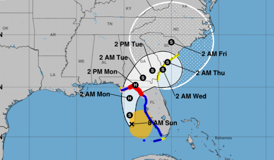
Where Debby is and where Debby is going: As of the 8 a.m. advisory, Debby was 155 miles southwest of Tampa and 205 miles south-southwest of Cedar Key. It’s moving north northwest at 13 mph.
“A turn toward the north is expected later (Sunday), followed by a slower motion toward the northeast on Monday and Tuesday,” the hurricane center said. The forecast expects that, “the center will move across the eastern Gulf of Mexico through tonight and reach the Florida Big Bend coast Monday morning. Debby is then expected to move slowly across northern Florida and southern Georgia Monday and Tuesday.”
Debby’s strength: Debby’s maximum sustained winds are measuring 60 mph with some stronger gusts. Tropical storm force winds have been measured up to 140 miles from the center.
“Continued strengthening is forecast, and Debby is expected to become a hurricane by (Sunday night) before it reaches the Florida Big Bend coast,” Weakening is expected on Monday and Tuesday after Debby moves inland.”
Watches and warnings: There are many.
The state’s west coast from the Suwannee River to the Ochlockonee River is under hurricane warning. Hurricane watches cover the west coast west of the Ochlockonee River to Indian Pass and south of the Suwannee River to Yankeetown.
The Florida Keys area west of the Seven Mile Bridge; the state coastal areas south of the Suwannee River to East Cape Sable; and west of the Ochlockonee River to Indian Pass are under tropical storm warning. A tropical storm watch covers the Keys area north of the Seven Mile Bridge to the Channel 5 Bridge; the state coast west of Indian Pass to Mexico Beach; the Georgia and South Carolina coasts from the Mouth of the St. Mary’s River to South Santee River.
Storm surge warnings cover the state coast from Aripeka northward to Indian Pass. A Storm surge watch is in effect for the coast from Bonita Beach northward to Aripeka, including Tampa Bay and Charlotte Harbor; and the Georgia and South Carolina coast from the Mouth of the St. Mary’s River to the South Santee River.
Hazards: Over the next five days, Debby is forecast to hit parts of north Florida with 6 to 12 inches of rain. Some areas could get 18 inches.
“This rainfall will likely result in areas of considerable flash and urban flooding, with significant river flooding expected,” the hurricane center said.
“For Cuba, additional rainfall amounts of 2 to 4 inches, with localized higher amounts, will be possible through (Sunday) morning. This will result in isolated to scattered areas of flooding.”
As for storm surge, “the combination of storm surge and tide will cause normally dry areas near the coast to be flooded by rising waters moving inland from the shoreline.”
The storm surge forecast is for 2 to 4 feet for the Tampa-St. Petersburg area, Charlotte Harbor, Bonita Beach to Aripeka, and the Mouth of the St. Mary’s River to South Santee River; 6 to 10 feet for the Suwannee River to Aucilla River area; 4 to 7 feet for the Yankeetown to Suwannee River and Aucilla to Ochlockonee River; and 3 to 5 feet for Ochlockonee River to Indian Pass.
Next advisory: The next complete advisory will be at 11 a.m.
Miami Herald Reporter Devoun Cetoute contributed to this report.
