Tropical Storm Debby creeps toward SC as rains have started dousing the Midlands
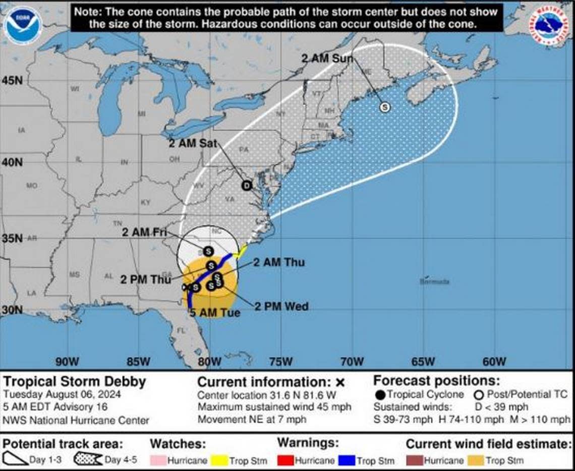
Tropical Storm Debby was slowly moving through Georgia early Tuesday morning as it headed toward South Carolina, where rain already began falling in the Columbia area.
Heavy to excessive rain is expected to continue in the Midlands throughout Tuesday, into the night and to the following days, the National Weather Service said in a morning briefing.
As rain continues Wednesday, Thursday and Friday, as much as 10 inches of precipitation could be recorded in the Columbia area, according to the briefing. Localized amounts in other areas of the Midlands could be higher, especially along the Interstate 20 corridor, and in the area south of the highway, the National Weather Service said.
All of that rain makes major flooding possible through the week as Debby makes a close approach to the area, according to the briefing.

Widespread, significant flooding could begin Tuesday and remains a threat through Thursday, the National Weather Service said.
A flood watch has already gone into effect, and it includes Richland, Lexington, Kershaw, Sumter, Lee, Clarendon, Calhoun and Orangeburg counties. The flood watch is currently listed as running through Thursday night.
On Tuesday morning, a flash flood warning was issued for part of Orangeburg, as well as Bamberg and Barnwell, according to the National Weather Service. That warning is valid through 12:15 p.m.
The possibility of continued heavy rainfall Wednesday and Thursday creates the potential for more flooding, the National Weather Service said in the briefing.
Excessive runoff could result in flooding of rivers, creeks, streams, and other low-lying and flood-prone locations, according to the National Weather Service. Extensive street flooding and flooding of creeks and rivers are possible.
Both the excessive rain and flooding are more likely because the tropical storm is moving slowly, according to the briefing. Debby is forecast to stall near the South Carolina coast through Wednesday, then move northwest into the Palmetto State on Thursday and Friday, the National Weather Service said.
As of 5 a.m. Tuesday, Tropical Storm Debby was moving northeast at 6 mph, and had maximum sustained winds of 45 mph, according to the National Hurricane Center. That’s slower than the 10 mph pace and 75 mph wind speeds recorded Monday morning when Debby was at hurricane-level strength.
As the storm was about 20 miles south of Savannah, Georgia on Tuesday morning, and 100 miles out from Charleston, it had tropical-storm-force winds that extended up to 205 miles out, the National Hurricane Center said.
The National Weather Service continues to maintain that Debby’s winds are not expected to be a major threat to the Columbia area. Wind gusts as fast as 30 mph are possible, and the National Hurricane Center said that a 48 mph gust was recorded at Winyah Bay Light near Georgetown, South Carolina.
The possibility of tornadoes cannot be ruled out, as a limited threat remains, the National Weather Service said in the briefing. Tornadoes could form Tuesday through Thursday, according to the briefing.
Powerful winds and tornadoes could cause considerable damage to trees and branches, in addition to mobile homes, roofs and outbuildings. Vehicles would also be under siege in the case of a tornado.
Damage to trees and branches creates the possibility of downed power lines and outages.
“We will see some strong winds from this storm, but the biggest concern is flooding,” South Carolina Emergency Management Division Director Kim Stenson said in a news release. “The heavy rains and flooding currently predicted this week are historic in scope and scale. Our experts with the National Hurricane Center believe flooding to be catastrophic for many parts of South Carolina. Take no chances with this storm.”
With so much rain expected, the South Carolina Department of Transportation urged drivers to watch weather reports and plan routes before hitting the road.
During a news conference Monday, Columbia Police Chief Skip Holbrook urged people to stay off the roads during the storm unless it was absolutely necessary.
“Drivers should never drive around barricades or through standing water,” SCDOT said.
Storm preparation
The South Carolina Emergency Management Division suggests residents take the following steps as Tropical Storm Debby approaches:
▪ Double Check Your Emergency Kit: Prepare an emergency kit with non-perishable food, water, medications, flashlights, batteries, a first-aid kit, and important documents. Make sure your kit can sustain your household for at least three days, but preferably with enough supplies to last a week or more.
▪ Clear Gutters and Drains: Make sure to clear your gutters and storm drains of debris to prevent water accumulation and reduce the risk of flooding around your home.
▪ Secure Outdoor Items: Store or secure outdoor furniture, garden tools, and toys. High winds can turn these objects into dangerous projectiles.
▪ Stay Informed: Monitor local weather forecasts and stay informed about the developments of the storm. Have several ways to get emergency information.
Source: South Carolina Emergency Management Division
