On a path to hit Florida, Tropical Storm Debby forms in Gulf of Mexico
Editor's Note: This page is a summary of news about Tropical Storm Debby for Saturday, Aug. 3. For the latest on the storm, view our story for Sunday, Aug. 4.
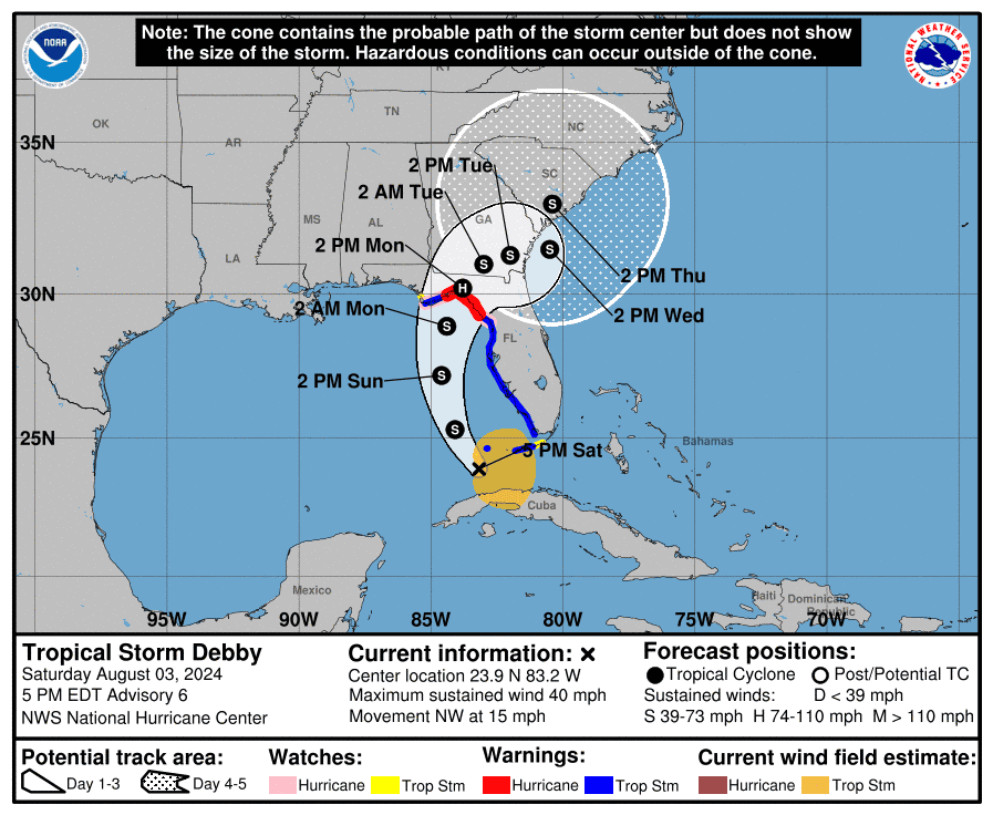
Tropical Storm Debby – the fourth named storm of the 2024 Atlantic hurricane season – formed Saturday in the Gulf of Mexico, the National Hurricane Center said. The storm follows Tropical Storms Alberto and Chris, and deadly and destructive Hurricane Beryl, which wreaked havoc across the U.S. in July.
Debby is expected to drench Florida and parts of the southeast U.S. coast, with as much as a foot of rain, and up to 18 inches in some areas, according to the hurricane center. Maximum sustained winds increased late Saturday night to nearly 45 mph, with stronger gusts. The storm is expected to become a hurricane by late Sunday before it hits the Florida Big Bend coast on Monday, forecasters said Saturday night. Debby is expected to weaken after it comes ashore.
The center warned some parts of the state will face tropical storm or hurricane conditions on Sunday. Some areas could see up to 4 to 7 feet of storm surge.
About 10 million people were under Tropical Storm Warnings as of Saturday afternoon, according to the National Weather Service.
Florida Gov. Ron DeSantis declared a state of emergency for most of the state's counties ahead of what could be the region's first major storm of the hurricane season.
A tropical depression turns into a named tropical storm once its reaches sustained winds of 39 mph. It would become a hurricane if its winds reach 74 mph.
Parts of Florida could face a Category 1 hurricane
AccuWeather meteorologists said the storm could strengthen into a Category 1 hurricane and make landfall in Florida’s Big Bend region early Monday morning.
Forecasters are concerned about the water temperatures in the path of the storm.
Temperatures in the eastern Gulf of Mexico are well above average, said Brandon Buckingham, an AccuWeather meteorologist. Those temperatures coupled with low wind shear could lead the storm to rapidly intensify over the weekend, Buckingham told USA TODAY on Saturday.
“It is not out of the question that we could see this hitting that hurricane strength in the hours leading up to landfall,” Buckingham said. “It’s not out of the realm of possibility that we could be talking, potentially, even a category higher.”
Kristian Oliver, a National Weather Service forecaster in Tallahassee, said the region will likely face a high-end tropical storm or low-end Category 1 hurricane.
"The difference between the two is very minor," he said, adding that residents should be prepared for a category higher. "With these things intensity can fluctuate quickly."
After making landfall, the storm's path is still uncertain, and forecasters aren't sure whether the storm will significantly slow as it moves over land, exacerbating impacts.
– Eduardo Cuevas, USA TODAY; and William L. Hatfield, the Tallahassee Democrat
Atlantic storm tracker
'Time to prepare' is now
Whether the storm makes landfall as a tropical storm or hurricane — or deviates from the current forecast path — millions of people in the south will face risks from wind, rain, flooding and possible tornadoes. Stormy weather could knock out power for days.
“Now is that time to prepare,” Brandon Buckingham, an AccuWeather meteorologist, told USA TODAY. “You don’t want to be caught off-guard or act too late.”
What to know:
Is it too late to get flood insurance? Yes – for this storm
Should I evacuate? Pay close attention to warnings and alerts from officials, and prepare to evacuate if ordered to do so.
What should I buy from the store? Drinking water, non-perishable food and any medications you take.
Have an EV? Move electric vehicles and scooters or golf carts with lithium ion batteries to higher ground; salty floodwaters can compromise the batteries and cause fires, officials warned.
Where can I go if I need help? The Florida Department of Health has opened shelters for people with medical needs or disabilities. You can pre-register here. Some counties have also opened shelters at schools for people evacuating.
-Eduardo Cuevas
DeSantis expands state of emergency
The Florida governor on Friday added seven more counties under a state of emergency, bringing the total to 61 out of the state's total 67 counties.
Atlantic storm spaghetti models
Illustrations include an array of forecast tools and models, and not all are created equal. The hurricane center uses only the top four or five highest performing models to help make its forecasts.
DeSantis had previously issued the order for 54 counties on Thursday.
See which counties are under a state of emergency here.
Watch out for tornadoes, especially at night
While the potential hurricane is brewing, forecasters say Floridians should be prepared for tornadoes, which are more dangerous at night.
One or two tornadoes could spawn across the Florida Keys and the western Florida peninsula Saturday night and across much of central and northern Florida on Sunday, according to the National Hurricane Center.
Nighttime tornadoes are up to two times more deadly than daytime tornadoes because people are sleeping and tornadoes are harder to spot at night, according to an AccuWeather release quoting senior meteorologist Jon Porter.
"Have your shelter or safe place ready for tornado warnings. You want to be able to move there quickly, especially with an overnight threat. You want to be in the lowest part of your home, ideally an interior room away from external walls, windows and doors,” Porter said.
Tornadoes aren't uncommon during hurricanes: In fact, almost all hurricanes and tropical storms that make landfall in the United States spawn at least one tornado, provided enough of the storm's circulation moves over land, according to the National Oceanic and Atmospheric Administration.
"These tornadoes most often occur in thunderstorms embedded in rain bands well away from the center of the hurricane," NOAA said. "However, they can also occur near the eyewall. Usually, tornadoes produced by tropical cyclones are relatively weak and short-lived, but they still pose a significant threat."
Contributing: Emily DeLetter and Doyle Rice
This article originally appeared on USA TODAY: Storm tracker: Tropical Storm Debby forms in Gulf of Mexico
