Tropical Storm Debby updates from the National Hurricane Center for Thursday, Aug 08
Article first published: Thursday, Aug. 08, 2024, 5 a.m. ET
Article last updated: Thursday, Aug. 08, 2024, 8 a.m. ET
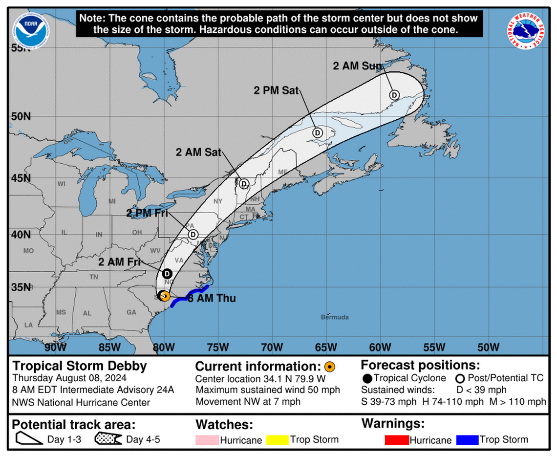
On Thursday at 8 am, the National Hurricane Center issued an advisory stating that Tropical Storm Debby is 65 miles west-northwest of Myrtle Beach South Carolina and 90 miles north of Charleston South Carolina, with maximum sustained wind of 50 mph. It’s moving 7 mph to the northwest.
"The storm is expected to accelerate toward the north-northwest and north across eastern South Carolina and central North Carolina through tonight." forecasters noted. "Debby is then expected to move faster toward the northeast across the U.S. Mid-Atlantic and Northeast on Friday and Atlantic Canada on Saturday." They also said "Continued weakening is forecast during the next day or so, and Debby is likely to become a tropical depression this afternoon or evening."
YESTERDAY (Wednesday):
Yesterday, South Carolina's coastline was expected to encounter Debby, coming from the Atlantic Ocean
SUMMARY OF WATCHES AND WARNINGS IN EFFECT:
A Tropical Storm Warning is in effect for:
- North of South Santee River, South Carolina to Ocracoke Inlet, North Carolina
A Tropical Storm Warning means that tropical storm conditions are expected somewhere within the warning area, in this case during the next 12 hours.
HAZARDS AFFECTING LAND:
WIND: Tropical storm conditions are expected to continue along the coasts of South Carolina and North Carolina within the tropical storm warning area for much of the day.
STORM SURGE: The combination of storm surge and tide will cause normally dry areas near the coast to be flooded by rising waters moving inland from the shoreline. The water could reach the following heights above ground somewhere in the indicated areas if the peak surge occurs at the time of high tide...
South Santee River to Ocracoke Inlet including the Neuse and Pamlico Rivers...1 to 3 ft
For a complete depiction of areas at risk of storm surge inundation, please see the National Weather Service Peak Storm Surge Graphic, available at hurricanes.gov/graphics_at4.shtml? PeakSurge.
RAINFALL: Debby is expected to produce an additional 3 to 6 inches of rainfall with locally higher amounts, across portions of southeastern North Carolina leading to maximum storm total amounts as high as 15 inches. Additional rainfall of 1 to 3 inches over portions of eastern South Carolina will bring maximum storm total amounts as high as 20 to 25 inches. Considerable flooding is expected across portions of eastern South Carolina and southeast North Carolina through Friday.
From central North Carolina northward across portions of Virginia, 3 to 7 inches with local amounts to 10 inches, are expected through Friday. This rainfall will likely result in areas of considerable flash and urban flooding, with river flooding possible.
From portions of Maryland north through Upstate New York and Vermont, 2 to 4 inches, with local amounts to 6 inches, are expected through Friday night. This will likely result in areas of considerable flash and urban flooding as well as river flooding.
For a complete depiction of forecast rainfall and flash flooding associated with Debby, please see the National Weather Service Storm Total Rainfall Graphic, available at hurricanes.gov/graphics_at4.shtml? Rainqpf and the Flash Flood Risk graphic at hurricanes.gov/graphics_at4.shtml? Ero. For a list of rainfall observations (and wind reports) associated this storm, see the companion storm summary at WBCSCCNS4 with the WMO header ACUS44 KWBC or at the following link: www.wpc.ncep.noaa.gov/discussions/nfdscc4.html.
TORNADOES: A few tornadoes may occur over parts of eastern North Carolina this morning. The tornado threat will shift northward later today into central North Carolina and southern to central Virginia.
SURF: Large swells will continue to affect the Southeast U.S. coast for another day or two. These conditions are likely to cause life-threatening surf and rip current conditions.
Source: National Hurricane Center
This article was generated by the South Carolina Bot, artificial intelligence software that analyzes information from the National Hurricane Center and applies it to templates created by journalists in the newsroom. We are experimenting with this and other new ways of providing more useful content to our readers and subscribers. You can report errors or bugs to mcclatchybot@mcclatchy.com.
