Drenching, severe storms to rumble over central US


A moisture-filled pattern will fuel robust thunderstorms throughout the first half of the week across parts of the Rocky Mountains and central United States, AccuWeather meteorologists say.
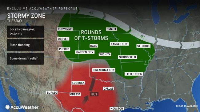
High pressure will remain centered over the South Central states over the next several days, expanding to cover more of the Gulf Coast states into midweek. However, rounds of thunderstorms are expected to organize along the northern periphery for a multi-day stretch.
 |
"A 'rinse and repeat' pattern is in store along the Front Range and central Plains through at least the middle of the week as monsoon moisture spills over the mountains during the afternoon and evening hours. Similar to what has been observed late this past week, showers and thunderstorms that track east of the mountains late in the day can congeal into clusters of rain and thunderstorms as they track eastward through the Plains during the overnight hours," explained AccuWeather Meteorologist Brandon Buckingham.
Areas of the West from Montana and Idaho to Colorado will be the areas to see the most consistent storm activity. While a severe weather outbreak is not expected, there will be enough moisture to produce disruptive thunderstorms.
 |
Midday and afternoon showers and thunderstorms that ignite over the upcoming days will be capable of producing pockets of intense rainfall that can result in flash flooding. Sensitive spots, such as burn scar locations and areas featuring steep terrain, can be the most susceptible to washouts and rockslides when combined with notable rainfall rates in storms.
There are still many locations from Montana to Oklahoma that are facing levels of moderate to severe drought, according to the U.S. Drought Monitor. Any additional rainfall may prove beneficial for the dry soils in this sector of the country, although it may come at the risk of other unfavorable impacts.
"The multiple rounds of rain and thunderstorms that are expected will also help to alleviate drought concerns, especially across portions of eastern Wyoming, western South Dakota, western Nebraska and Kansas where moderate to severe drought is currently in place," reiterated Buckingham.
 |
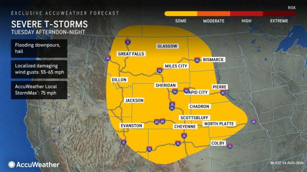
On Tuesday, a corridor from eastern Idaho, Utah and Montana to western, Nebraska, North Dakota and South Dakota will face some risk for severe thunderstorms as energy pulses across the Rockies.
 |
The primary threats within storms on Tuesday will be flooding downpours, localized damaging winds and hail. Wind gusts can reach speeds of 55-65 miles per hour from southeast Montana to far northwest Kansas with the AccuWeather Local StormMax™ of 75 mph.
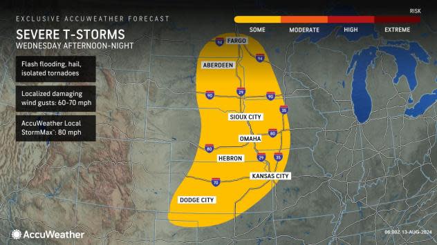
The rounds of severe weather is expected to continue into the middle of the week on Wednesday as well. Thunderstorms firing up from the Dakotas to the Texas and Oklahoma panhandles on Wednesday afternoon could again contain flash flooding, hail an damaging winds through the evening. The strongest storms could contain a tornado or two.
 |
As this storm moves eastward, thunderstorms are expected to be most concentrated from Minnesota to Missouri and Illinois on Thursday before moving into the Great Lakes Friday. Widespread severe weather is not expected with the thunderstorms at the end of the week, although localized flash flooding and gusty winds are a possibility.
Want next-level safety, ad-free? Unlock advanced, hyperlocal severe weather alerts when you subscribe to Premium+ on the AccuWeather app. AccuWeather Alerts™ are prompted by our expert meteorologists who monitor and analyze dangerous weather risks 24/7 to keep you and your family safer.
