Ernesto, other storms to soak Britain into Saturday
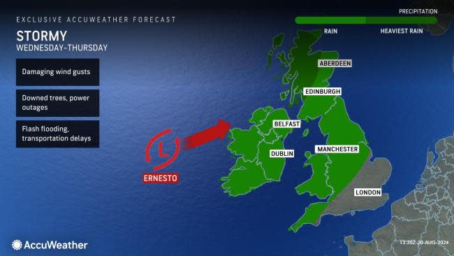
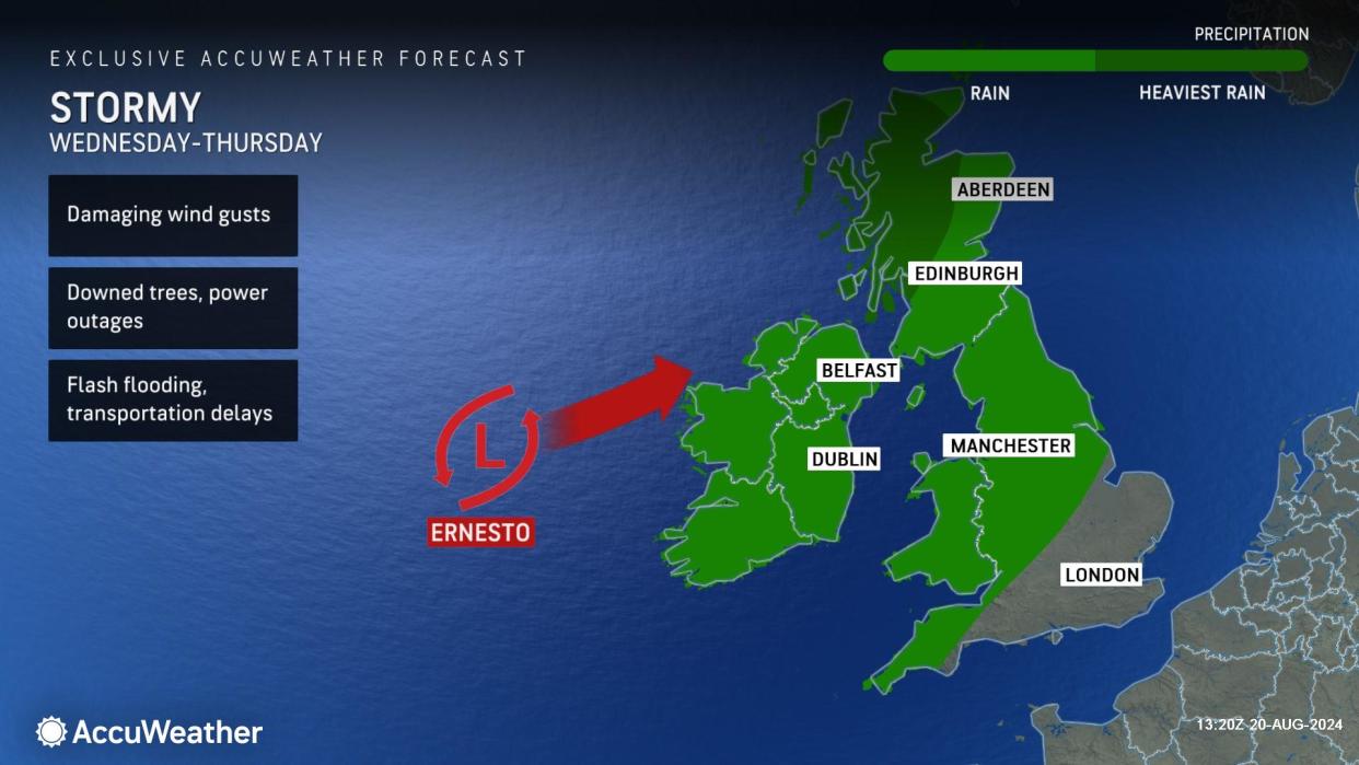
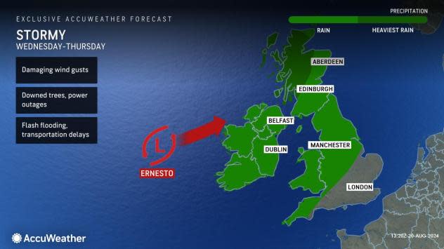
A series of storms that includes Tropical Wind and Rainstorm Ernesto will sweep across Ireland and the United Kingdom this weekend and result in travel delays, risks from flash flooding, and damage from gusty winds, AccuWeather meteorologists advise.
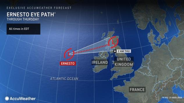
Ernesto was a Category 1 hurricane when it passed about 70 miles (113 km) to the southeast of Cape Race, Newfoundland, Monday night, after tracking directly across Bermuda Saturday morning. It has since transitioned to what AccuWeather calls a tropical wind and rainstorm.
 |
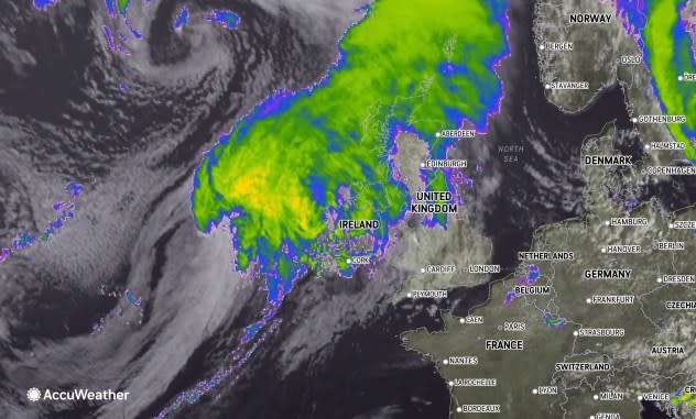
This image of the North Atlantic was captured on Wednesday, Aug. 21, 2024 and shows Tropical Wind and Rainstorm Ernesto (left of center) approaching Ireland and the United Kingdom. (AccuWeather Enhanced RealVue™ Satellite) |
Even though Ernesto will slowly lose some wind intensity, its forward speed will accelerate across the North Atlantic, and it will cross the northern parts of the British Isles from later Wednesday to early Thursday as a tropical wind and rainstorm.
The forward speed of Ernesto, perhaps approaching 50 mph (80 km/h), will limit the duration of its rain and wind, but for a brief period, these conditions may be locally intense.
While every tropical wind and rainstorm is different, there have been dozens of officially post-tropical storms that have caused significant damage and put lives in danger in recent decades. One of the most significant examples of a post-tropical storm was Sandy in 2012, which struck the mid-Atlantic region of the United States and resulted in hundreds of fatalities and nearly $70 billion in damage in 2012 dollars.
AccuWeather meteorologists continue to track such storms, as they often tend to hold on to dangerous qualities they once possessed while in the tropics. This can put lives and property at risk for many days after the National Hurricane Center declares them post-tropical.
 |
Ernesto is not expected to come close to the scope of damage Sandy caused in the U.S. years ago, but it will still pack enough punch to bring strong wind gusts, rough seas and heavy rain with the most substantial conditions to target northwestern Scotland. While these areas tend to get hit hard fairly often during the winter season, this rare summertime storm can disrupt outdoor activities and force outdoor café dining areas at local restaurants to retreat indoors.
As if Ernesto's impacts were not bad enough, a front-running storm will bring locally drenching rain to Ireland, Northern Ireland, Scotland, and northern England into Wednesday. This storm will moisten the ground so that much of Ernesto's rain may rapidly run off from Wednesday night to Thursday, leading to flash flooding in some areas and water collecting in locations that drain poorly, especially in Scotland.
 |
Yet another storm will follow right on the heels of Ernesto from Thursday to Friday. The bulk of the rain from the late-week storm will focus from Ireland to southern Scotland and northern England with lesser showers farther to the south over Wales and southern England. The Thursday to Friday storm will also pack a fair amount of wind with it, more typical of a storm in the winter. So once again, there may be some trouble from broken tree limbs and sporadic power outages with the tree canopy being full.
The areas where the heaviest rain from all three storms overlap will be the most prone to significant flash flooding, road washouts, rockslides, and other debris flows.
Much of the northern half of the British Isles can expect 2-4 inches (50-100 mm) of rain with 4-6 inches (100-150 mm) of rain and locally higher amounts in northwestern Scotland from the storm trio.
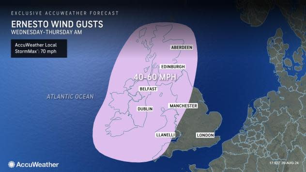
Tropical-storm-force wind gusts of 40-50 mph (65-80 km/h) are likely in the northern and western portions of the British Isles, with local gusts to 60 mph (97 km/h) along the west-facing coasts of Ireland, Northern Ireland, and Scottland.
 |
One last, much weaker storm will slice eastward from Friday night to Saturday, and it is that feature that is most likely to bring a few hours of soaking rain to Wales and southern England, including London.
Areas that were hit with multiple rounds of rain into Friday may be spared most of that storm's downpours.
Want next-level safety, ad-free? Unlock advanced, hyperlocal severe weather alerts when you subscribe to Premium+ on the AccuWeather app. AccuWeather Alerts™ are prompted by our expert meteorologists who monitor and analyze dangerous weather risks 24/7 to keep you and your family safer.
