Florida on long-range alert for upcoming Gulf tropical threat

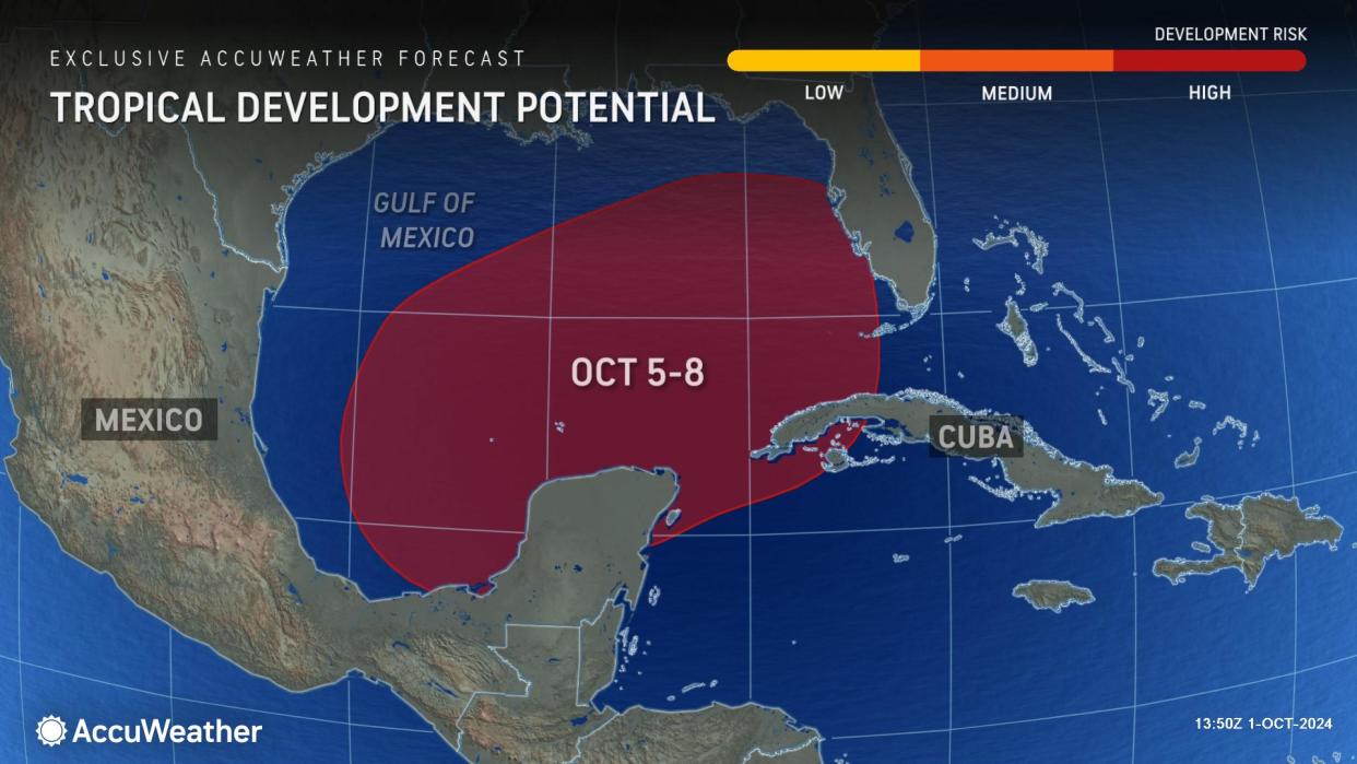
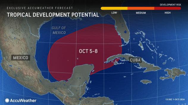


The Gulf of Mexico remains the zone to watch for tropical development and impacts to the United States in the days ahead, and this time Florida may be the prime target for any budding system next week.
Last week, even as Helene was moving inland with deadly and destructive flooding, AccuWeather's long-range and hurricane experts pointed out that the next new threat to the U.S. would likely be from the Gulf of Mexico and the western Caribbean. That development zone is being narrowed down to the southern gulf, and the birth of a new storm could occur as early as this weekend or early next week.
 |
AccuWeather meteorologists have labeled the Gulf threat as a high risk of development, just as they did for Helene.
"Water temperatures continue to remain warm in the wake of Helene over the southeastern Gulf of Mexico," AccuWeather Lead Hurricane Expert Alex DaSilva said. "Not only is the surface water warm, but it remains warm down deep so that wave action from any storm has little cooling effect."
The minimum water temperature for full tropical development is 78-80 F. Water temperatures in the southern Gulf of Mexico and northwestern Caribbean Sea remain well into the 80s.
 |
But it takes more than warm water to spin up a tropical system. There needs to be an impetus for development, and disruptive breezes (wind shear) must be light.
Disorganized pockets of showers and thunderstorms will gather and grow in the waters surrounding southern Mexico and western Cuba in the coming days.
 |
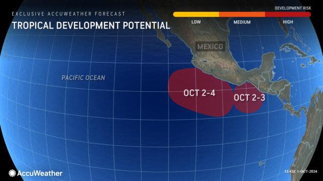
"There are two features--two scenarios we are looking at this week," AccuWeather Chief On-Air Meteorologist Bernie Rayno said. "One scenario has to do with a non-tropical storm at mid-levels of the atmosphere coming in from the Caribbean, and the other scenario is a budding tropical system near the Mexico shores of the eastern Pacific."
The mid-level storm is creating a significant amount of wind shear, so any feature that tries to spin up in the western Caribbean would have a big hurdle to overcome and would likely remain weak or perhaps limited to a tropical depression or tropical storm. The amount of time for development would be shorter in this case as steering breezes would tend to push the feature across the land (Florida) within a couple of days after formation.
 |
"The system in the eastern Pacific has a chance of becoming a tropical depression or storm in the next couple of days," DaSilva said.
If it were to move northward and survive into the southwestern gulf, it would retain the eastern Pacific name, but it is difficult for a storm's circulation to remain intact when crossing the mountains of Central America.
 |
"Regardless, that energy could spawn a development in the southwestern Gulf of Mexico from later this weekend to early next week," Da Silva said. "This seems like the bigger threat for more high-end development, such as a hurricane, as it would tend to spend more time, perhaps an extra two days or more, over the warm waters of the gulf."
Rayno said that breezes next week would tend to guide any budding tropical feature to the eastern shores of the Gulf of Mexico rather than the central Gulf coast.
"This really looks like a threat of heavy rain and possibly a wind and surge threat, depending on storm strength, for Florida later next week," Rayno stated.
 |
It is early yet, but interests in Florida, from the northeastern Gulf Coast to the Keys, as well as inland areas of the Sunshine State, should closely monitor the situation. Conditions may deteriorate from the middle to the latter part of next week with impacts from heavy rain and wind.
Once confidence builds on the feature's starting point or a center is on the verge of forming, AccuWeather will likely declare a tropical rainstorm to begin issuing its own track maps.
At this early stage, a northward path into the far interior Southeast, including the Helene-devasted southern Appalachians, seems unlikely, but meteorologists will continue to monitor all aspects of the weather pattern closely.
Elsewhere in the Atlantic, Kirk, which formed in late September, is likely to strengthen rapidly and become a major hurricane of Category 3 strength or greater on the Saffir-Simpson Hurricane Wind scale.
"There is little to inhibit Kirk, and a high-end hurricane that is mostly a threat to central Atlantic shipping is forecast for mid- to late week," Da Silva said.
 |
Because few obstacles are in its way, Kirk has the potential to last a long time. It could go on to impact part of western Europe, perhaps as a tropical wind and rainstorm, toward mid-October.
AccuWeather meteorologists are also watching for tropical development just north of the equator in the western Atlantic in the next few days.
 |
The next names on the list of tropical storms and hurricanes for the 2024 Atlantic season are Leslie and Milton. Joyce formed in late September over the middle of the ocean and is struggling as a tropical rainstorm nearly 1,000 miles to the northeast of the northern Leeward Islands in the Caribbean.
Want next-level safety, ad-free? Unlock advanced, hyperlocal severe weather alerts when you subscribe to Premium+ on the AccuWeather app. AccuWeather Alerts™ are prompted by our expert meteorologists who monitor and analyze dangerous weather risks 24/7 to keep you and your family safer.
