Scorching late-summer heat wave to bring highest temperatures of the year so far to Los Angeles


Some of the hottest weather of the year so far will settle over the Los Angeles area as a late-summer heat wave sprawls from California, Nevada and Arizona to Oregon, Washington and Idaho, AccuWeather meteorologists say.
 |
A strong area of high pressure has over California and will linger into the weekend, with the center of the high over Southern California, Nevada, western Arizona and southwestern Utah. The position of the high pressure area will create offshore breezes, which will help to push the warmth toward the beaches.
"September is traditionally one of the hotter months of the year in Los Angeles," AccuWeather Senior Meteorologist Heather Zehr said.
Zehr explained that Southern California cools down from the peak of summer heat more slowly than areas farther north. Pacific Ocean water temperatures are also higher after the long days of summer, which tends to reduce the difference between the land and sea temperatures and reduce the effects of the marine influence.
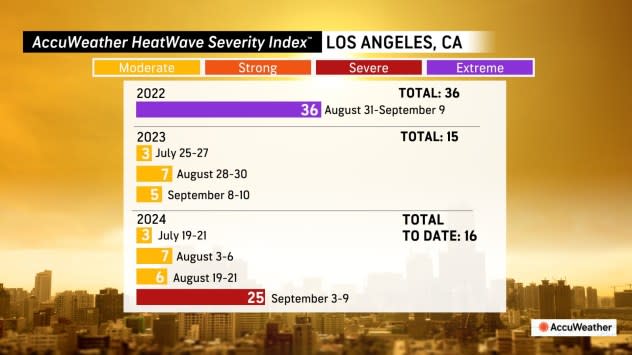
"The pattern will deliver the longest stretch of heat that the Los Angeles Basin, in particular, has seen so far this year. In downtown L.A., high temperatures will remain at or above 90 for seven days through Monday," Zehr said, "Historically, every day in September has a record high of at least 100 degrees with the highest September record being 113 on Sept. 27, 2010. This is also the all-time record for downtown Los Angeles."
 |
"It is possible that temperatures in downtown L.A. exceed 100 Friday," AccuWeather Senior Meteorologist Dave Houk said.
Most places will top out 10-20 degrees Fahrenheit above historical averages, with coastal areas at least 5 above average. Along the Southern California coast, widespread highs in the upper 80s to mid-90s are in store with highs over the interior deserts in the low 100s to 110s. Excessive heat warnings, issued by the National Weather Service, will expand from the San Fernando Valley into the rest of Southern California remain in effect into Saturday evening.
Surging heat and energy demands in major population centers, such as Los Angeles and San Diego, could result in rolling blackouts.
The buildup of heat in urban areas can be dangerous for those who do not have access to air conditioning. By the time the inner cities cool down in the early morning hours, the sun is already climbing on the horizon and beginning to heat the landscape at the start of the new day.
 |
"Nighttime temperatures will be on the warmer side as well with a lot of spots getting lows in the 70s; the warmest spots may not drop below 80. Additionally, the next couple of days will also be a bit on the humid side which can make it feel even hotter," Zehr said.
This heat wave over the interior West will not be as extreme as that of July for most of the rest of the region.
During the three-month period (meteorological summer) from June 1 through Aug. 31, 2024, multiple locations over the interior West have had their hottest summer on record. In some cases, records date back to the 1800s.
 |
"Phoenix will end up with similar temps to what they had then, but it won't be as extreme as July for places like the Central Valley of California and into the deserts," Zehr said.
Las Vegas and Redding, California, are just a few locations that set all-time record highs in July. Las Vegas hit 120 degrees on July 7, while Redding reached 119 on July 6. Phoenix had 13 days in a row with highs of 110 or greater with a total of 25 days for the month of July. The highest temperature in Phoenix in July was 118.
 |
"The Northwest is the most likely part of the West to end up with daily records since they typically cool down more quickly in September and are subject to outbreaks of polar air as opposed to the Southwest," Zehr said, "Parts of the Willamette Valley will experience triple-digit heat."
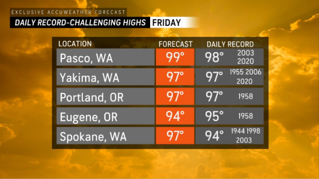
While Portland, Oregon, did not hit its high mark of 104 set on July 9, the city exceeded 100 for the first time since then on Thursday. The July heat wave was responsible for three days in a row of triple-digit temperatures. Thursday's high of 102 shattered the old record of 93 set in 1987. Highs are forecast to be well into the 90s in Portland through Friday.
 |
Along with the heat and the brush that has dried out all summer, the risk of wildfires will increase with the rising temperatures this week. People are urged to use extreme caution when using outdoor power equipment and open flames. Driving vehicles through high brush can also start a fire. The exhaust system of a fully warmed-up vehicle is hot enough to ignite the brush that comes in contact.
During this weekend, the strong area of high pressure will weaken and shift farther inland over the West as a storm from the Gulf of Alaska drops southeastward.
As the upper portion of the atmosphere cools off faster than near the ground, thunderstorms may erupt and turn severe in coastal areas of the Northwest Saturday, Houk said. Any lightning strikes that occur without drenching downpours can spark new wildfires.
 |
As the high pressure area shifts inland, temperatures will trend downward for the Pacific Coast states beginning later this weekend with a more substantial drop early next week.
Want next-level safety, ad-free? Unlock advanced, hyperlocal severe weather alerts when you subscribe to Premium+ on the AccuWeather app. AccuWeather Alerts™ are prompted by our expert meteorologists who monitor and analyze dangerous weather risks 24/7 to keep you and your family safer.
